Schnaitsee geodata
Schnaitsee (Bavaria) is a seat of a fourth-order administrative division; located in Germany in Europe/Berlin (GMT+2) time zone. With population of 3,571 people, there are 3562 cities with bigger population in this country. Compared to other cities in Germany, 94.6% of cities are located further ↑North; 86.6% of cities are located further ←West and 94.1% of cities have lower elevation than Schnaitsee. Note1
Administrative division(s):
- Level 1: Bavaria
- Level 2: Upper Bavaria
- Level 3: Landkreis Traunstein
- Level 4: Schnaitsee


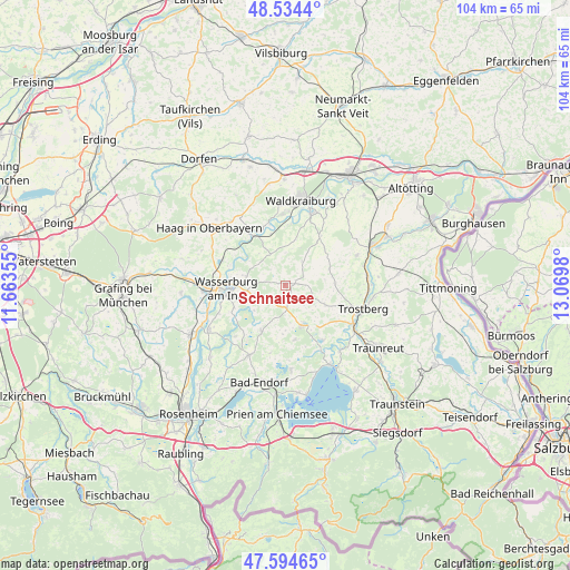
Schnaitsee GPS coordinates[2]
48° 4' 0.012" North, 12° 22' 0.012" East
| Map corner | latitude | longitude |
|---|---|---|
| Upper-left | 48.5344°, | 11.66355° |
| Center: | 48.06667°, | 12.36667° |
| Lower-right: | 47.59465°, | 13.0698° |
| Map W x H: | 104.5×104.5 km | = 64.9×64.9mi |
| max Lat: | 55.01917° ⇑94.6% North |
| Schnaitsee: | 48.06667° |
| min Lat: | ⇓5.4% South 47.40724° |
| min Long | Schnaitsee | max Long |
| 5.92978° | 12.36667° | 14.98853° |
| W 86.6%⇐ | ⇒13.4% E |
Elevation
Elevation of Schnaitsee is 576 m = 1890 ft, and this is 326.9 m = 1073 ft above average elevation for this country.
| Max E: |
1256 m = 4121 ft | 5.9% |
| Schnaitsee | 576 m 1890 ft | |
| Avg. | 249.1 m = 817 ft | |
Min E: |
-5 m = -16 ft | 94.1% |
See also: Germany elevation on elevation.city.
Geographical zone
Schnaitsee is located in North temperate zone (between Tropic of Cancer and the Arctic Circle). Distance of this North polar circle is 2056.7 km =1278 mi to North.| Distance of | km | miles | from Schnaitsee |
|---|---|---|---|
| North Pole | 4662.5 | 2897.1 | to North |
| Arctic Circle | 2056.7 | 1278 | to North |
| Tropic Cancer | 2738.6 | 1701.7 | to South |
| Equator | 5344.5 | 3320.9 | to South |


Nearby cities:
15 places around Schnaitsee: (largest is in red/bold)
• Amerang
9.4 km =5.8 mi,  207°
207°
• Babensham
7.7 km =4.8 mi,  284°
284°
• Eiselfing
9.6 km =6 mi,  252°
252°
• Gars
11.7 km =7.3 mi,  325°
325°
• Höslwang
12.9 km =8 mi,  192°
192°
• Jettenbach
11.2 km =7 mi,  6°
6°
• Kienberg
8 km =5 mi,  116°
116°
• Obing
7.9 km =4.9 mi,  158°
158°
• Pittenhart
10.1 km =6.3 mi,  170°
170°
• Schonstett
12.7 km =7.9 mi,  223°
223°
• Schönberg
6.1 km =3.8 mi,  262°
262°
• Soyen
12.5 km =7.8 mi,  291°
291°
• Taufkirchen
11.1 km =6.9 mi,  33°
33°
• Unterreit
6.1 km =3.8 mi,  335°
335°
• Wasserburg am Inn
10.8 km =6.7 mi, 261°
Sources, notices
• [Note1] Compared only with cities in Germany existing in our database
• [Src1] Map data: © OpenStreetMap contributors (CC-BY-SA)
• [Src2] Other city data from geonames.org with taken over terms of usage.
• [Src3] Geographical zone / Annual Mean Temperature by Robert A. Rohde @ Wikipedia
