Furth geodata
Furth (Bavaria) is a populated place; located in Germany in Europe/Berlin (GMT+2) time zone. With population of 3,236 people, there are 3802 cities with bigger population in this country. Compared to other cities in Germany, 90.1% of cities are located further ↑North; 86.7% of cities are located further ←West and 85.9% of cities have lower elevation than Furth. Note1
Administrative division(s):
- Level 1: Bavaria
- Level 2: Lower Bavaria
- Level 3: Landkreis Landshut
- Level 4: Bodenkirchen


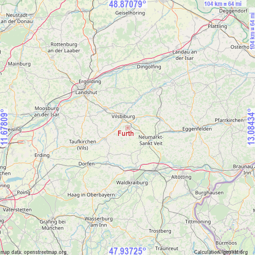
Furth GPS coordinates[2]
48° 24' 22.176" North, 12° 22' 52.356" East
| Map corner | latitude | longitude |
|---|---|---|
| Upper-left | 48.87079°, | 11.67809° |
| Center: | 48.40616°, | 12.38121° |
| Lower-right: | 47.93725°, | 13.08434° |
| Map W x H: | 103.8×103.8 km | = 64.5×64.5mi |
| max Lat: | 55.01917° ⇑90.1% North |
| Furth: | 48.40616° |
| min Lat: | ⇓9.9% South 47.40724° |
| min Long | Furth | max Long |
| 5.92978° | 12.38121° | 14.98853° |
| W 86.7%⇐ | ⇒13.3% E |
Elevation
Elevation of Furth is 477 m = 1565 ft, and this is 227.9 m = 748 ft above average elevation for this country.
| Max E: |
1256 m = 4121 ft | 14.1% |
| Furth | 477 m 1565 ft | |
| Avg. | 249.1 m = 817 ft | |
Min E: |
-5 m = -16 ft | 85.9% |
See also: Germany elevation on elevation.city.
Geographical zone
Furth is located in North temperate zone (between Tropic of Cancer and the Arctic Circle). Distance of this North polar circle is 2018.9 km =1254.5 mi to North.| Distance of | km | miles | from Furth |
|---|---|---|---|
| North Pole | 4624.8 | 2873.7 | to North |
| Arctic Circle | 2018.9 | 1254.5 | to North |
| Tropic Cancer | 2776.3 | 1725.1 | to South |
| Equator | 5382.3 | 3344.4 | to South |


Nearby cities:
15 places around Furth: (largest is in red/bold)
• Bodenkirchen
2.5 km =1.6 mi,  176°
176°
• Buchbach
13.1 km =8.1 mi,  217°
217°
• Egglkofen
5.1 km =3.2 mi,  97°
97°
• Geisenhausen
12 km =7.5 mi,  310°
310°
• Gerzen
11.7 km =7.3 mi,  16°
16°
• Lohkirchen
11.2 km =7 mi,  152°
152°
• Neufraunhofen
12.2 km =7.6 mi,  266°
266°
• Neumarkt-Sankt Veit
10.6 km =6.6 mi,  118°
118°
• Niederbergkirchen
13.3 km =8.3 mi,  138°
138°
• Oberbergkirchen
11.8 km =7.3 mi, 179°
• Schalkham
9 km =5.6 mi, 16°
• Schönberg
9 km =5.6 mi, 154°
• Velden
10.3 km =6.4 mi,  244°
244°
• Vilsbiburg
5.5 km =3.4 mi,  340°
340°
• Wurmsham
7.2 km =4.5 mi,  209°
209°
Sources, notices
• [Note1] Compared only with cities in Germany existing in our database
• [Src1] Map data: © OpenStreetMap contributors (CC-BY-SA)
• [Src2] Other city data from geonames.org with taken over terms of usage.
• [Src3] Geographical zone / Annual Mean Temperature by Robert A. Rohde @ Wikipedia
