Vilsbiburg geodata
Vilsbiburg (Bavaria) is a populated place; located in Germany in Europe/Berlin (GMT+2) time zone. With population of 11,416 people, there are 1447 cities with bigger population in this country. Compared to other cities in Germany, 89.7% of cities are located further ↑North; 86.5% of cities are located further ←West and 82.4% of cities have lower elevation than Vilsbiburg. Note1
Administrative division(s):
- Level 1: Bavaria
- Level 2: Lower Bavaria
- Level 3: Landkreis Landshut
- Level 4: Vilsbiburg


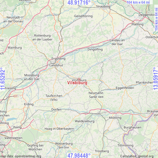
Vilsbiburg GPS coordinates[2]
48° 27' 10.656" North, 12° 21' 21.744" East
| Map corner | latitude | longitude |
|---|---|---|
| Upper-left | 48.91716°, | 11.65292° |
| Center: | 48.45296°, | 12.35604° |
| Lower-right: | 47.98448°, | 13.05917° |
| Map W x H: | 103.7×103.7 km | = 64.4×64.4mi |
| max Lat: | 55.01917° ⇑89.7% North |
| Vilsbiburg: | 48.45296° |
| min Lat: | ⇓10.3% South 47.40724° |
| min Long | Vilsbiburg | max Long |
| 5.92978° | 12.35604° | 14.98853° |
| W 86.5%⇐ | ⇒13.5% E |
Elevation
Elevation of Vilsbiburg is 449 m = 1473 ft, and this is 199.9 m = 656 ft above average elevation for this country.
| Max E: |
1256 m = 4121 ft | 17.6% |
| Vilsbiburg | 449 m 1473 ft | |
| Avg. | 249.1 m = 817 ft | |
Min E: |
-5 m = -16 ft | 82.4% |
See also: Germany elevation on elevation.city.
Geographical zone
Vilsbiburg is located in North temperate zone (between Tropic of Cancer and the Arctic Circle). Distance of this North polar circle is 2013.7 km =1251.3 mi to North.| Distance of | km | miles | from Vilsbiburg |
|---|---|---|---|
| North Pole | 4619.6 | 2870.5 | to North |
| Arctic Circle | 2013.7 | 1251.3 | to North |
| Tropic Cancer | 2781.5 | 1728.3 | to South |
| Equator | 5387.5 | 3347.6 | to South |


Nearby cities:
15 places around Vilsbiburg: (largest is in red/bold)
• Adlkofen
12.6 km =7.8 mi,  328°
328°
• Aham
11.2 km =7 mi,  43°
43°
• Altfraunhofen
14 km =8.7 mi,  268°
268°
• Baierbach
12.2 km =7.6 mi,  250°
250°
• Bodenkirchen
8 km =5 mi,  165°
165°
• Egglkofen
9.1 km =5.7 mi,  130°
130°
• Eging
12.3 km =7.6 mi,  275°
275°
• Furth
5.5 km =3.4 mi,  160°
160°
• Geisenhausen
7.7 km =4.8 mi,  289°
289°
• Gerzen
8 km =5 mi, 40°
• Neufraunhofen
11.8 km =7.3 mi,  240°
240°
• Schalkham
5.6 km =3.5 mi,  52°
52°
• Schönberg
14.5 km =9 mi, 156°
• Velden
12.1 km =7.5 mi,  217°
217°
• Wurmsham
11.6 km =7.2 mi,  188°
188°
Sources, notices
• [Note1] Compared only with cities in Germany existing in our database
• [Src1] Map data: © OpenStreetMap contributors (CC-BY-SA)
• [Src2] Other city data from geonames.org with taken over terms of usage.
• [Src3] Geographical zone / Annual Mean Temperature by Robert A. Rohde @ Wikipedia
