Geisenhausen geodata
Geisenhausen (Bavaria) is a populated place; located in Germany in Europe/Berlin (GMT+2) time zone. With population of 6,367 people, there are 2345 cities with bigger population in this country. Compared to other cities in Germany, 89.4% of cities are located further ↑North; 85.3% of cities are located further ←West and 83.9% of cities have lower elevation than Geisenhausen. Note1
Administrative division(s):
- Level 1: Bavaria
- Level 2: Lower Bavaria
- Level 3: Landkreis Landshut
- Level 4: Geisenhausen, Markt


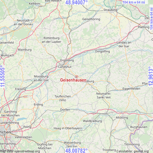
Geisenhausen GPS coordinates[2]
48° 28' 33.924" North, 12° 15' 29.412" East
| Map corner | latitude | longitude |
|---|---|---|
| Upper-left | 48.94007°, | 11.55505° |
| Center: | 48.47609°, | 12.25817° |
| Lower-right: | 48.00782°, | 12.9613° |
| Map W x H: | 103.7×103.7 km | = 64.4×64.4mi |
| max Lat: | 55.01917° ⇑89.4% North |
| Geisenhausen: | 48.47609° |
| min Lat: | ⇓10.6% South 47.40724° |
| min Long | Geisenhausen | max Long |
| 5.92978° | 12.25817° | 14.98853° |
| W 85.3%⇐ | ⇒14.7% E |
Elevation
Elevation of Geisenhausen is 461 m = 1512 ft, and this is 211.9 m = 695 ft above average elevation for this country.
| Max E: |
1256 m = 4121 ft | 16.1% |
| Geisenhausen | 461 m 1512 ft | |
| Avg. | 249.1 m = 817 ft | |
Min E: |
-5 m = -16 ft | 83.9% |
See also: Germany elevation on elevation.city.
Geographical zone
Geisenhausen is located in North temperate zone (between Tropic of Cancer and the Arctic Circle). Distance of this North polar circle is 2011.1 km =1249.6 mi to North.| Distance of | km | miles | from Geisenhausen |
|---|---|---|---|
| North Pole | 4617 | 2868.9 | to North |
| Arctic Circle | 2011.1 | 1249.6 | to North |
| Tropic Cancer | 2784.1 | 1730 | to South |
| Equator | 5390 | 3349.2 | to South |


Nearby cities:
15 places around Geisenhausen: (largest is in red/bold)
• Adlkofen
8.2 km =5.1 mi,  4°
4°
• Altfraunhofen
7.3 km =4.5 mi,  246°
246°
• Baierbach
7.9 km =4.9 mi,  212°
212°
• Eging
5.3 km =3.3 mi, 254°
• Furth
12 km =7.5 mi,  130°
130°
• Gerzen
12.9 km =8 mi,  74°
74°
• Kumhausen
8.4 km =5.2 mi,  296°
296°
• Landshut
9.3 km =5.8 mi,  309°
309°
• Neufraunhofen
9 km =5.6 mi,  199°
199°
• Schalkham
11.7 km =7.3 mi,  86°
86°
• Stallwang
9.4 km =5.8 mi,  347°
347°
• Tiefenbach
12 km =7.5 mi,  282°
282°
• Velden
12.2 km =7.6 mi,  180°
180°
• Vilsbiburg
7.7 km =4.8 mi,  109°
109°
• Vilsheim
11.6 km =7.2 mi, 254°
Sources, notices
• [Note1] Compared only with cities in Germany existing in our database
• [Src1] Map data: © OpenStreetMap contributors (CC-BY-SA)
• [Src2] Other city data from geonames.org with taken over terms of usage.
• [Src3] Geographical zone / Annual Mean Temperature by Robert A. Rohde @ Wikipedia
