Frömmstedt geodata
Frömmstedt (Thuringia) is a seat of a fourth-order administrative division; located in Germany in Europe/Berlin (GMT+2) time zone. With population of 614 people, there are 8750 cities with bigger population in this country. Compared to other cities in Germany, 62.6% of cities are located further ↓South; 67.5% of cities are located further ←West and 58.1% of cities have higher elevation than Frömmstedt. Note1
Administrative division(s):
- Level 1: Thuringia
- Level 3: Landkreis Sömmerda
- Level 4: Stadt Kindelbrück


Frömmstedt GPS coordinates[2]
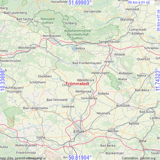
51° 15' 40.104" North, 11° 2' 24.36" East
| Map corner | latitude | longitude |
|---|---|---|
| Upper-left | 51.69903°, | 10.33698° |
| Center: | 51.26114°, | 11.0401° |
| Lower-right: | 50.81904°, | 11.74323° |
| Map W x H: | 97.8×97.8 km | = 60.8×60.8mi |
| max Lat: | 55.01917° ⇑37.4% North |
| Frömmstedt: | 51.26114° |
| min Lat: | ⇓62.6% South 47.40724° |
| min Long | Frömmstedt | max Long |
| 5.92978° | 11.0401° | 14.98853° |
| W 67.5%⇐ | ⇒32.5% E |
Elevation
Elevation of Frömmstedt is 167 m = 548 ft, and this is 82.1 m = 269 ft below average elevation for this country.
| Max E: |
1256 m = 4121 ft | 58.1% |
| Avg. | 249.1 m = 817 ft | |
| Frömmstedt | 167 m = 548 ft | |
Min E: |
-5 m = -16 ft | 41.9% |
See also: Germany elevation on elevation.city.
Geographical zone
Frömmstedt is located in North temperate zone (between Tropic of Cancer and the Arctic Circle). Distance of this North polar circle is 1701.5 km =1057.3 mi to North.| Distance of | km | miles | from Frömmstedt |
|---|---|---|---|
| North Pole | 4307.4 | 2676.5 | to North |
| Arctic Circle | 1701.5 | 1057.3 | to North |
| Tropic Cancer | 3093.8 | 1922.4 | to South |
| Equator | 5699.7 | 3541.6 | to South |


Nearby cities:
15 places around Frömmstedt: (largest is in red/bold)
• Bilzingsleben
3.1 km =1.9 mi,  36°
36°
• Büchel
7.7 km =4.8 mi,  99°
99°
• Clingen
8.1 km =5 mi,  246°
246°
• Greußen
7.5 km =4.7 mi,  242°
242°
• Griefstedt
7.1 km =4.4 mi,  119°
119°
• Günstedt
5.2 km =3.2 mi,  147°
147°
• Herrnschwende
5.7 km =3.5 mi,  209°
209°
• Kannawurf
6.5 km =4 mi,  84°
84°
• Kindelbrück
3.5 km =2.2 mi,  88°
88°
• Niederbösa
2.9 km =1.8 mi,  282°
282°
• Oberbösa
3.5 km =2.2 mi,  332°
332°
• Riethgen
5.5 km =3.4 mi, 103°
• Topfstedt
5.1 km =3.2 mi, 276°
• Trebra
4.7 km =2.9 mi,  301°
301°
• Weißensee
7.1 km =4.4 mi,  163°
163°
Sources, notices
• [Note1] Compared only with cities in Germany existing in our database
• [Src1] Map data: © OpenStreetMap contributors (CC-BY-SA)
• [Src2] Other city data from geonames.org with taken over terms of usage.
• [Src3] Geographical zone / Annual Mean Temperature by Robert A. Rohde @ Wikipedia
