Bohnsdorf geodata
Bohnsdorf (Berlin) is a section of populated place; located in Germany in Europe/Berlin (GMT+2) time zone. With population of 10,805 people, there are 1530 cities with bigger population in this country. Compared to other cities in Germany, 76.1% of cities are located further ↓South; 96.2% of cities are located further ←West and 84.1% of cities have higher elevation than Bohnsdorf. Note1


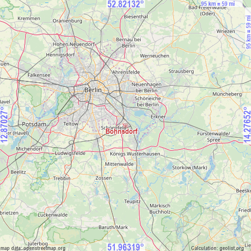
Bohnsdorf GPS coordinates[2]
52° 23' 39.624" North, 13° 34' 24.204" East
| Map corner | latitude | longitude |
|---|---|---|
| Upper-left | 52.82132°, | 12.87027° |
| Center: | 52.39434°, | 13.57339° |
| Lower-right: | 51.96319°, | 14.27652° |
| Map W x H: | 95.4×95.4 km | = 59.3×59.3mi |
| max Lat: | 55.01917° ⇑23.9% North |
| Bohnsdorf: | 52.39434° |
| min Lat: | ⇓76.1% South 47.40724° |
| min Long | Bohnsdorf | max Long |
| 5.92978° | 13.57339° | 14.98853° |
| W 96.2%⇐ | ⇒3.8% E |
Elevation
Elevation of Bohnsdorf is 37 m = 121 ft, and this is 212.1 m = 696 ft below average elevation for this country.
| Max E: |
1256 m = 4121 ft | 84.1% |
| Avg. | 249.1 m = 817 ft | |
| Bohnsdorf | 37 m = 121 ft | |
Min E: |
-5 m = -16 ft | 15.9% |
See also: Germany elevation on elevation.city.
Geographical zone
Bohnsdorf is located in North temperate zone (between Tropic of Cancer and the Arctic Circle). Distance of this North polar circle is 1575.5 km =979 mi to North.| Distance of | km | miles | from Bohnsdorf |
|---|---|---|---|
| North Pole | 4181.4 | 2598.2 | to North |
| Arctic Circle | 1575.5 | 979 | to North |
| Tropic Cancer | 3219.8 | 2000.7 | to South |
| Equator | 5825.7 | 3619.9 | to South |


Nearby cities:
15 places around Bohnsdorf: (largest is in red/bold)
• Adlershof
4.9 km =3 mi,  339°
339°
• Altglienicke
3.2 km =2 mi,  306°
306°
• Berlin Köpenick
5.4 km =3.4 mi,  6°
6°
• Eichwalde
4.3 km =2.7 mi,  136°
136°
• Friedrichshagen
7.1 km =4.4 mi,  29°
29°
• Grünau
2.5 km =1.6 mi, 10°
• Johannisthal
7.4 km =4.6 mi,  322°
322°
• Köpenick
5.7 km =3.5 mi,  0°
0°
• Müggelheim
6.4 km =4 mi,  72°
72°
• Niederschöneweide
7.9 km =4.9 mi,  330°
330°
• Rudow
6.8 km =4.2 mi,  298°
298°
• Schmöckwitz
5.6 km =3.5 mi,  112°
112°
• Schulzendorf
4.4 km =2.7 mi,  157°
157°
• Schönefeld
4.8 km =3 mi,  262°
262°
• Zeuthen
6.1 km =3.8 mi,  147°
147°
Sources, notices
• [Note1] Compared only with cities in Germany existing in our database
• [Src1] Map data: © OpenStreetMap contributors (CC-BY-SA)
• [Src2] Other city data from geonames.org with taken over terms of usage.
• [Src3] Geographical zone / Annual Mean Temperature by Robert A. Rohde @ Wikipedia
