Bad Sooden-Allendorf geodata
Bad Sooden-Allendorf (Hesse) is a populated place; located in Germany in Europe/Berlin (GMT+2) time zone. With population of 8,915 people, there are 1806 cities with bigger population in this country. Compared to other cities in Germany, 62.8% of cities are located further ↓South; 50.4% of cities are located further →East and 59.3% of cities have higher elevation than Bad Sooden-Allendorf. Note1
Administrative division(s):
- Level 1: Hesse
- Level 2: Regierungsbezirk Kassel
- Level 3: Werra-Meißner-Kreis
- Level 4: Bad Sooden-Allendorf


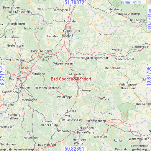
Bad Sooden-Allendorf GPS coordinates[2]
51° 16' 15.312" North, 9° 58' 29.388" East
| Map corner | latitude | longitude |
|---|---|---|
| Upper-left | 51.70872°, | 9.27171° |
| Center: | 51.27092°, | 9.97483° |
| Lower-right: | 50.82891°, | 10.67796° |
| Map W x H: | 97.8×97.8 km | = 60.8×60.8mi |
| max Lat: | 55.01917° ⇑37.2% North |
| Bad Sooden-Allendorf: | 51.27092° |
| min Lat: | ⇓62.8% South 47.40724° |
| min Long | Bad Sooden-Alle | max Long |
| 5.92978° | 9.97483° | 14.98853° |
| W 49.6%⇐ | ⇒50.4% E |
Elevation
Elevation of Bad Sooden-Allendorf is 158 m = 518 ft, and this is 91.1 m = 299 ft below average elevation for this country.
| Max E: |
1256 m = 4121 ft | 59.3% |
| Avg. | 249.1 m = 817 ft | |
| Bad Sooden-Allendorf | 158 m = 518 ft | |
Min E: |
-5 m = -16 ft | 40.7% |
See also: Germany elevation on elevation.city.
Geographical zone
Bad Sooden-Allendorf is located in North temperate zone (between Tropic of Cancer and the Arctic Circle). Distance of this North polar circle is 1700.4 km =1056.6 mi to North.| Distance of | km | miles | from Bad Sooden-Allendorf |
|---|---|---|---|
| North Pole | 4306.3 | 2675.8 | to North |
| Arctic Circle | 1700.4 | 1056.6 | to North |
| Tropic Cancer | 3094.9 | 1923.1 | to South |
| Equator | 5700.8 | 3542.3 | to South |


Nearby cities:
15 places around Bad Sooden-Allendorf: (largest is in red/bold)
• Birkenfelde
9.3 km =5.8 mi,  18°
18°
• Bornhagen
7.2 km =4.5 mi,  346°
346°
• Eichstruth
8.2 km =5.1 mi,  66°
66°
• Fretterode
5.4 km =3.4 mi, 18°
• Gerbershausen
7 km =4.3 mi,  4°
4°
• Kella
8.6 km =5.3 mi,  118°
118°
• Lindewerra
5.4 km =3.4 mi,  341°
341°
• Mackenrode
7.2 km =4.5 mi,  63°
63°
• Pfaffschwende
9 km =5.6 mi,  104°
104°
• Röhrig
8 km =5 mi,  30°
30°
• Schwobfeld
8.8 km =5.5 mi,  80°
80°
• Schönhagen
8.2 km =5.1 mi, 22°
• Volkerode
6.4 km =4 mi,  94°
94°
• Wahlhausen
3.3 km =2.1 mi,  10°
10°
• Wüstheuterode
8.3 km =5.2 mi,  45°
45°
Sources, notices
• [Note1] Compared only with cities in Germany existing in our database
• [Src1] Map data: © OpenStreetMap contributors (CC-BY-SA)
• [Src2] Other city data from geonames.org with taken over terms of usage.
• [Src3] Geographical zone / Annual Mean Temperature by Robert A. Rohde @ Wikipedia
