Freilassing geodata
Freilassing (Bavaria) is a populated place; located in Germany in Europe/Berlin (GMT+2) time zone. With population of 15,909 people, there are 1011 cities with bigger population in this country. Compared to other cities in Germany, 97.3% of cities are located further ↑North; 92.2% of cities are located further ←West and 78.5% of cities have lower elevation than Freilassing. Note1
Administrative division(s):
- Level 1: Bavaria
- Level 2: Upper Bavaria
- Level 3: Berchtesgadener Land
- Level 4: Freilassing


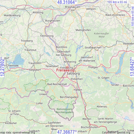
Freilassing GPS coordinates[2]
47° 50' 27.06" North, 12° 58' 52.104" East
| Map corner | latitude | longitude |
|---|---|---|
| Upper-left | 48.31064°, | 12.27802° |
| Center: | 47.84085°, | 12.98114° |
| Lower-right: | 47.36677°, | 13.68427° |
| Map W x H: | 104.9×104.9 km | = 65.2×65.2mi |
| max Lat: | 55.01917° ⇑97.3% North |
| Freilassing: | 47.84085° |
| min Lat: | ⇓2.7% South 47.40724° |
| min Long | Freilassing | max Long |
| 5.92978° | 12.98114° | 14.98853° |
| W 92.2%⇐ | ⇒7.8% E |
Elevation
Elevation of Freilassing is 423 m = 1388 ft, and this is 173.9 m = 571 ft above average elevation for this country.
| Max E: |
1256 m = 4121 ft | 21.5% |
| Freilassing | 423 m 1388 ft | |
| Avg. | 249.1 m = 817 ft | |
Min E: |
-5 m = -16 ft | 78.5% |
See also: Germany elevation on elevation.city.
Geographical zone
Freilassing is located in North temperate zone (between Tropic of Cancer and the Arctic Circle). Distance of this North polar circle is 2081.8 km =1293.6 mi to North.| Distance of | km | miles | from Freilassing |
|---|---|---|---|
| North Pole | 4687.7 | 2912.8 | to North |
| Arctic Circle | 2081.8 | 1293.6 | to North |
| Tropic Cancer | 2713.5 | 1686.1 | to South |
| Equator | 5319.4 | 3305.3 | to South |


Nearby cities:
15 places around Freilassing: (largest is in red/bold)
• Ainring
4.3 km =2.7 mi,  224°
224°
• Anger
10.2 km =6.3 mi,  244°
244°
• Bad Reichenhall
14.6 km =9.1 mi,  211°
211°
• Bayerisch Gmain
15.1 km =9.4 mi,  203°
203°
• Fridolfing
20.9 km =13 mi,  326°
326°
• Inzell
19.2 km =11.9 mi, 243°
• Kirchanschöring
16.6 km =10.3 mi,  318°
318°
• Laufen
11.2 km =7 mi,  339°
339°
• Marktschellenberg
16.7 km =10.4 mi,  163°
163°
• Petting
14.7 km =9.1 mi,  302°
302°
• Piding
9.6 km =6 mi, 210°
• Sankt Leonhard am Wonneberg
21.2 km =13.2 mi,  292°
292°
• Surberg
21.2 km =13.2 mi,  277°
277°
• Teisendorf
12.1 km =7.5 mi,  274°
274°
• Waging am See
21.2 km =13.2 mi, 299°
Sources, notices
• [Note1] Compared only with cities in Germany existing in our database
• [Src1] Map data: © OpenStreetMap contributors (CC-BY-SA)
• [Src2] Other city data from geonames.org with taken over terms of usage.
• [Src3] Geographical zone / Annual Mean Temperature by Robert A. Rohde @ Wikipedia
