Bad Reichenhall geodata
Bad Reichenhall (Bavaria) is a seat of a third-order administrative division; located in Germany in Europe/Berlin (GMT+2) time zone. With population of 16,910 people, there are 936 cities with bigger population in this country. Compared to other cities in Germany, 98.5% of cities are located further ↑North; 91.3% of cities are located further ←West and 85.1% of cities have lower elevation than Bad Reichenhall. Note1
Administrative division(s):
- Level 1: Bavaria
- Level 2: Upper Bavaria
- Level 3: Berchtesgadener Land
- Level 4: Bad Reichenhall


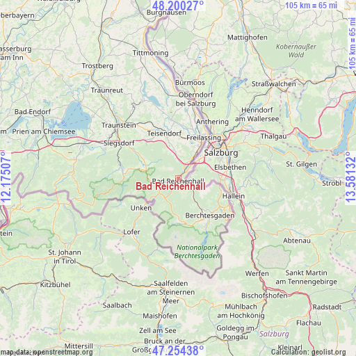
Bad Reichenhall GPS coordinates[2]
47° 43' 46.092" North, 12° 52' 41.484" East
| Map corner | latitude | longitude |
|---|---|---|
| Upper-left | 48.20027°, | 12.17507° |
| Center: | 47.72947°, | 12.87819° |
| Lower-right: | 47.25438°, | 13.58132° |
| Map W x H: | 105.2×105.2 km | = 65.4×65.4mi |
| max Lat: | 55.01917° ⇑98.5% North |
| Bad Reichenhall: | 47.72947° |
| min Lat: | ⇓1.5% South 47.40724° |
| min Long | Bad Reichenhall | max Long |
| 5.92978° | 12.87819° | 14.98853° |
| W 91.3%⇐ | ⇒8.7% E |
Elevation
Elevation of Bad Reichenhall is 470 m = 1542 ft, and this is 220.9 m = 725 ft above average elevation for this country.
| Max E: |
1256 m = 4121 ft | 14.9% |
| Bad Reichenhall | 470 m 1542 ft | |
| Avg. | 249.1 m = 817 ft | |
Min E: |
-5 m = -16 ft | 85.1% |
See also: Germany elevation on elevation.city.
Geographical zone
Bad Reichenhall is located in North temperate zone (between Tropic of Cancer and the Arctic Circle). Distance of this North polar circle is 2094.2 km =1301.3 mi to North.| Distance of | km | miles | from Bad Reichenhall |
|---|---|---|---|
| North Pole | 4700 | 2920.4 | to North |
| Arctic Circle | 2094.2 | 1301.3 | to North |
| Tropic Cancer | 2701.1 | 1678.4 | to South |
| Equator | 5307 | 3297.6 | to South |


Nearby cities:
15 places around Bad Reichenhall: (largest is in red/bold)
• Ainring
10.4 km =6.5 mi,  26°
26°
• Anger
8.2 km =5.1 mi,  349°
349°
• Bayerisch Gmain
2.2 km =1.4 mi,  131°
131°
• Berchtesgaden
14.2 km =8.8 mi,  139°
139°
• Bischofswiesen
13.5 km =8.4 mi, 144°
• Freilassing
14.6 km =9.1 mi, 31°
• Inzell
10.2 km =6.3 mi,  291°
291°
• Marktschellenberg
12.9 km =8 mi,  106°
106°
• Piding
5 km =3.1 mi, 34°
• Ramsau
12.6 km =7.8 mi,  172°
172°
• Ruhpolding
17.6 km =10.9 mi,  283°
283°
• Schneizlreuth
7.8 km =4.8 mi,  228°
228°
• Schönau am Königssee
16.5 km =10.3 mi,  150°
150°
• Surberg
20.2 km =12.6 mi,  318°
318°
• Teisendorf
14 km =8.7 mi,  341°
341°
Sources, notices
• [Note1] Compared only with cities in Germany existing in our database
• [Src1] Map data: © OpenStreetMap contributors (CC-BY-SA)
• [Src2] Other city data from geonames.org with taken over terms of usage.
• [Src3] Geographical zone / Annual Mean Temperature by Robert A. Rohde @ Wikipedia
