Inzell geodata
Inzell (Bavaria) is a seat of a fourth-order administrative division; located in Germany in Europe/Berlin (GMT+2) time zone. With population of 4,320 people, there are 3123 cities with bigger population in this country. Compared to other cities in Germany, 98.1% of cities are located further ↑North; 90.3% of cities are located further ←West and 97.7% of cities have lower elevation than Inzell. Note1
Administrative division(s):
- Level 1: Bavaria
- Level 2: Upper Bavaria
- Level 3: Landkreis Traunstein
- Level 4: Inzell


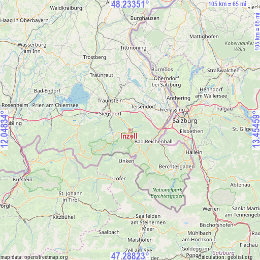
Inzell GPS coordinates[2]
47° 45' 46.872" North, 12° 45' 5.256" East
| Map corner | latitude | longitude |
|---|---|---|
| Upper-left | 48.23351°, | 12.04834° |
| Center: | 47.76302°, | 12.75146° |
| Lower-right: | 47.28823°, | 13.45459° |
| Map W x H: | 105.1×105.1 km | = 65.3×65.3mi |
| max Lat: | 55.01917° ⇑98.1% North |
| Inzell: | 47.76302° |
| min Lat: | ⇓1.9% South 47.40724° |
| min Long | Inzell | max Long |
| 5.92978° | 12.75146° | 14.98853° |
| W 90.3%⇐ | ⇒9.7% E |
Elevation
Elevation of Inzell is 696 m = 2283 ft, and this is 446.9 m = 1466 ft above average elevation for this country.
| Max E: |
1256 m = 4121 ft | 2.3% |
| Inzell | 696 m 2283 ft | |
| Avg. | 249.1 m = 817 ft | |
Min E: |
-5 m = -16 ft | 97.7% |
See also: Germany elevation on elevation.city.
Geographical zone
Inzell is located in North temperate zone (between Tropic of Cancer and the Arctic Circle). Distance of this North polar circle is 2090.4 km =1298.9 mi to North.| Distance of | km | miles | from Inzell |
|---|---|---|---|
| North Pole | 4696.3 | 2918.1 | to North |
| Arctic Circle | 2090.4 | 1298.9 | to North |
| Tropic Cancer | 2704.8 | 1680.7 | to South |
| Equator | 5310.7 | 3299.9 | to South |


Nearby cities:
15 places around Inzell: (largest is in red/bold)
• Ainring
15.2 km =9.4 mi,  68°
68°
• Anger
9.1 km =5.7 mi,  61°
61°
• Bad Reichenhall
10.2 km =6.3 mi,  111°
111°
• Bayerisch Gmain
12.2 km =7.6 mi, 114°
• Bergen
13.1 km =8.1 mi,  292°
292°
• Petting
17.3 km =10.7 mi,  15°
15°
• Piding
12.4 km =7.7 mi,  88°
88°
• Ruhpolding
7.6 km =4.7 mi,  273°
273°
• Sankt Leonhard am Wonneberg
17.1 km =10.6 mi,  351°
351°
• Schneizlreuth
9.6 km =6 mi,  157°
157°
• Siegsdorf
10.5 km =6.5 mi,  309°
309°
• Surberg
12.1 km =7.5 mi,  341°
341°
• Teisendorf
10.8 km =6.7 mi,  27°
27°
• Traunstein
14.2 km =8.8 mi,  325°
325°
• Vachendorf
14 km =8.7 mi, 309°
Sources, notices
• [Note1] Compared only with cities in Germany existing in our database
• [Src1] Map data: © OpenStreetMap contributors (CC-BY-SA)
• [Src2] Other city data from geonames.org with taken over terms of usage.
• [Src3] Geographical zone / Annual Mean Temperature by Robert A. Rohde @ Wikipedia
