Umkirch geodata
Umkirch (Baden-Württemberg) is a seat of a fourth-order administrative division; located in Germany in Europe/Berlin (GMT+2) time zone. With population of 5,208 people, there are 2734 cities with bigger population in this country. Compared to other cities in Germany, 95.1% of cities are located further ↑North; 81.8% of cities are located further →East and 52.7% of cities have higher elevation than Umkirch. Note1
Administrative division(s):
- Level 1: Baden-Württemberg
- Level 2: Freiburg Region
- Level 3: Landkreis Breisgau-Hochschwarzwald
- Level 4: Umkirch


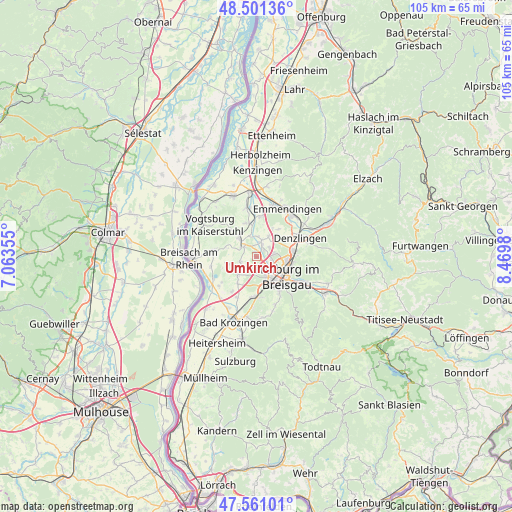
Umkirch GPS coordinates[2]
48° 1' 59.988" North, 7° 46' 0.012" East
| Map corner | latitude | longitude |
|---|---|---|
| Upper-left | 48.50136°, | 7.06355° |
| Center: | 48.03333°, | 7.76667° |
| Lower-right: | 47.56101°, | 8.4698° |
| Map W x H: | 104.6×104.6 km | = 65×65mi |
| max Lat: | 55.01917° ⇑95.1% North |
| Umkirch: | 48.03333° |
| min Lat: | ⇓4.9% South 47.40724° |
| min Long | Umkirch | max Long |
| 5.92978° | 7.76667° | 14.98853° |
| W 18.2%⇐ | ⇒81.8% E |
Elevation
Elevation of Umkirch is 206 m = 676 ft, and this is 43.1 m = 141 ft below average elevation for this country.
| Max E: |
1256 m = 4121 ft | 52.7% |
| Avg. | 249.1 m = 817 ft | |
| Umkirch | 206 m = 676 ft | |
Min E: |
-5 m = -16 ft | 47.3% |
See also: Germany elevation on elevation.city.
Geographical zone
Umkirch is located in North temperate zone (between Tropic of Cancer and the Arctic Circle). Distance of this North polar circle is 2060.4 km =1280.3 mi to North.| Distance of | km | miles | from Umkirch |
|---|---|---|---|
| North Pole | 4666.3 | 2899.5 | to North |
| Arctic Circle | 2060.4 | 1280.3 | to North |
| Tropic Cancer | 2734.9 | 1699.4 | to South |
| Equator | 5340.8 | 3318.6 | to South |


Nearby cities:
15 places around Umkirch: (largest is in red/bold)
• Bahlingen
9.9 km =6.2 mi,  348°
348°
• Buchheim
3 km =1.9 mi,  8°
8°
• Bötzingen
5.7 km =3.5 mi,  327°
327°
• Denzlingen
9.4 km =5.8 mi,  66°
66°
• Ebringen
8.4 km =5.2 mi,  175°
175°
• Eichstetten
7 km =4.3 mi, 345°
• Freiburg
7.6 km =4.7 mi,  123°
123°
• Gottenheim
3.1 km =1.9 mi,  306°
306°
• Gundelfingen
7.4 km =4.6 mi,  82°
82°
• Ihringen
8.9 km =5.5 mi,  276°
276°
• Merdingen
6.5 km =4 mi,  253°
253°
• Merzhausen
8.9 km =5.5 mi,  146°
146°
• Schallstadt
8.3 km =5.2 mi, 184°
• Vörstetten
7.2 km =4.5 mi,  59°
59°
• Wittnau
10 km =6.2 mi,  158°
158°
Sources, notices
• [Note1] Compared only with cities in Germany existing in our database
• [Src1] Map data: © OpenStreetMap contributors (CC-BY-SA)
• [Src2] Other city data from geonames.org with taken over terms of usage.
• [Src3] Geographical zone / Annual Mean Temperature by Robert A. Rohde @ Wikipedia
