Stuttgart Feuerbach geodata
Stuttgart Feuerbach (Baden-Württemberg) is a section of populated place; located in Germany in Europe/Berlin (GMT+2) time zone. With population of 28,046 people, there are 505 cities with bigger population in this country. Compared to other cities in Germany, 85.2% of cities are located further ↑North; 63% of cities are located further →East and 59.4% of cities have lower elevation than Stuttgart Feuerbach. Note1
Administrative division(s):
- Level 1: Baden-Württemberg
- Level 2: Regierungsbezirk Stuttgart
- Level 3: Stadtkreis Stuttgart
- Level 4: Stuttgart


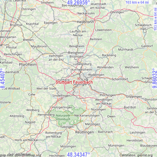
Stuttgart Feuerbach GPS coordinates[2]
48° 48' 31.212" North, 9° 9' 25.884" East
| Map corner | latitude | longitude |
|---|---|---|
| Upper-left | 49.26959°, | 8.45407° |
| Center: | 48.80867°, | 9.15719° |
| Lower-right: | 48.34347°, | 9.86032° |
| Map W x H: | 103×103 km | = 64×64mi |
| max Lat: | 55.01917° ⇑85.2% North |
| Stuttgart Feuerbach: | 48.80867° |
| min Lat: | ⇓14.8% South 47.40724° |
| min Long | Stuttgart Feuer | max Long |
| 5.92978° | 9.15719° | 14.98853° |
| W 37%⇐ | ⇒63% E |
Elevation
Elevation of Stuttgart Feuerbach is 286 m = 938 ft, and this is 36.9 m = 121 ft above average elevation for this country.
| Max E: |
1256 m = 4121 ft | 40.6% |
| Stuttgart Feuerbach | 286 m 938 ft | |
| Avg. | 249.1 m = 817 ft | |
Min E: |
-5 m = -16 ft | 59.4% |
See also: Germany elevation on elevation.city.
Geographical zone
Stuttgart Feuerbach is located in North temperate zone (between Tropic of Cancer and the Arctic Circle). Distance of this North polar circle is 1974.2 km =1226.7 mi to North.| Distance of | km | miles | from Stuttgart Feuerbach |
|---|---|---|---|
| North Pole | 4580 | 2845.9 | to North |
| Arctic Circle | 1974.2 | 1226.7 | to North |
| Tropic Cancer | 2821.1 | 1752.9 | to South |
| Equator | 5427 | 3372.2 | to South |


Nearby cities:
15 places around Stuttgart Feuerbach: (largest is in red/bold)
• Asperg
10.9 km =6.8 mi,  351°
351°
• Ditzingen
6.9 km =4.3 mi,  286°
286°
• Fellbach
8.8 km =5.5 mi,  89°
89°
• Gerlingen
7 km =4.3 mi,  261°
261°
• Hemmingen
11.1 km =6.9 mi,  305°
305°
• Korntal
3.7 km =2.3 mi, 314°
• Kornwestheim
6.2 km =3.9 mi,  19°
19°
• Leonberg
10.3 km =6.4 mi, 264°
• Ludwigsburg
10.2 km =6.3 mi,  14°
14°
• Möglingen
9 km =5.6 mi, 345°
• Ostfildern
11.3 km =7 mi,  143°
143°
• Schwieberdingen
9.7 km =6 mi,  321°
321°
• Stuttgart
3.3 km =2.1 mi,  153°
153°
• Stuttgart Mühlhausen
6.5 km =4 mi,  55°
55°
• Stuttgart-Ost
4.8 km =3 mi,  125°
125°
Sources, notices
• [Note1] Compared only with cities in Germany existing in our database
• [Src1] Map data: © OpenStreetMap contributors (CC-BY-SA)
• [Src2] Other city data from geonames.org with taken over terms of usage.
• [Src3] Geographical zone / Annual Mean Temperature by Robert A. Rohde @ Wikipedia
