Gerlingen geodata
Gerlingen (Baden-Württemberg) is a populated place; located in Germany in Europe/Berlin (GMT+2) time zone. With population of 19,050 people, there are 821 cities with bigger population in this country. Compared to other cities in Germany, 85.4% of cities are located further ↑North; 64.6% of cities are located further →East and 67.7% of cities have lower elevation than Gerlingen. Note1
Administrative division(s):
- Level 1: Baden-Württemberg
- Level 2: Regierungsbezirk Stuttgart
- Level 3: Landkreis Ludwigsburg
- Level 4: Gerlingen


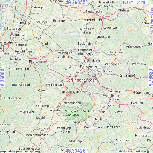
Gerlingen GPS coordinates[2]
48° 47' 58.344" North, 9° 3' 47.376" East
| Map corner | latitude | longitude |
|---|---|---|
| Upper-left | 49.26055°, | 8.36004° |
| Center: | 48.79954°, | 9.06316° |
| Lower-right: | 48.33426°, | 9.76629° |
| Map W x H: | 103×103 km | = 64×64mi |
| max Lat: | 55.01917° ⇑85.4% North |
| Gerlingen: | 48.79954° |
| min Lat: | ⇓14.6% South 47.40724° |
| min Long | Gerlingen | max Long |
| 5.92978° | 9.06316° | 14.98853° |
| W 35.4%⇐ | ⇒64.6% E |
Elevation
Elevation of Gerlingen is 341 m = 1119 ft, and this is 91.9 m = 302 ft above average elevation for this country.
| Max E: |
1256 m = 4121 ft | 32.3% |
| Gerlingen | 341 m 1119 ft | |
| Avg. | 249.1 m = 817 ft | |
Min E: |
-5 m = -16 ft | 67.7% |
See also: Germany elevation on elevation.city.
Geographical zone
Gerlingen is located in North temperate zone (between Tropic of Cancer and the Arctic Circle). Distance of this North polar circle is 1975.2 km =1227.3 mi to North.| Distance of | km | miles | from Gerlingen |
|---|---|---|---|
| North Pole | 4581.1 | 2846.6 | to North |
| Arctic Circle | 1975.2 | 1227.3 | to North |
| Tropic Cancer | 2820.1 | 1752.3 | to South |
| Equator | 5426 | 3371.6 | to South |


Nearby cities:
15 places around Gerlingen: (largest is in red/bold)
• Ditzingen
3 km =1.9 mi,  5°
5°
• Eberdingen
11.4 km =7.1 mi,  321°
321°
• Hemmingen
7.8 km =4.8 mi,  343°
343°
• Korntal
5.6 km =3.5 mi,  49°
49°
• Kornwestheim
11.3 km =7 mi, 52°
• Leonberg
3.4 km =2.1 mi,  270°
270°
• Magstadt
9.3 km =5.8 mi,  229°
229°
• Möglingen
10.8 km =6.7 mi,  25°
25°
• Renningen
9.7 km =6 mi,  250°
250°
• Rutesheim
8.7 km =5.4 mi,  276°
276°
• Schwieberdingen
8.6 km =5.3 mi, 5°
• Stuttgart
8.6 km =5.3 mi,  102°
102°
• Stuttgart Feuerbach
7 km =4.3 mi,  81°
81°
• Stuttgart-Ost
10.9 km =6.8 mi, 99°
• Weissach
11.2 km =7 mi,  298°
298°
Sources, notices
• [Note1] Compared only with cities in Germany existing in our database
• [Src1] Map data: © OpenStreetMap contributors (CC-BY-SA)
• [Src2] Other city data from geonames.org with taken over terms of usage.
• [Src3] Geographical zone / Annual Mean Temperature by Robert A. Rohde @ Wikipedia
