Grethem geodata
Grethem (Lower Saxony) is a seat of a fourth-order administrative division; located in Germany in Europe/Berlin (GMT+2) time zone. With population of 677 people, there are 8441 cities with bigger population in this country. Compared to other cities in Germany, 79.9% of cities are located further ↓South; 56.6% of cities are located further →East and 88.3% of cities have higher elevation than Grethem. Note1


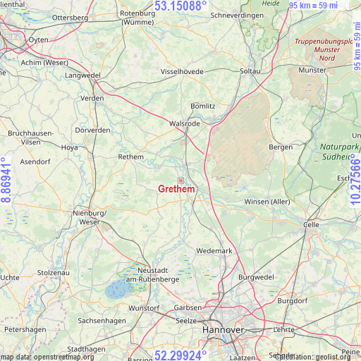
Grethem GPS coordinates[2]
52° 43' 37.704" North, 9° 34' 21.108" East
| Map corner | latitude | longitude |
|---|---|---|
| Upper-left | 53.15088°, | 8.86941° |
| Center: | 52.72714°, | 9.57253° |
| Lower-right: | 52.29924°, | 10.27566° |
| Map W x H: | 94.7×94.7 km | = 58.8×58.8mi |
| max Lat: | 55.01917° ⇑20.1% North |
| Grethem: | 52.72714° |
| min Lat: | ⇓79.9% South 47.40724° |
| min Long | Grethem | max Long |
| 5.92978° | 9.57253° | 14.98853° |
| W 43.4%⇐ | ⇒56.6% E |
Elevation
Elevation of Grethem is 26 m = 85 ft, and this is 223.1 m = 732 ft below average elevation for this country.
| Max E: |
1256 m = 4121 ft | 88.3% |
| Avg. | 249.1 m = 817 ft | |
| Grethem | 26 m = 85 ft | |
Min E: |
-5 m = -16 ft | 11.7% |
See also: Germany elevation on elevation.city.
Geographical zone
Grethem is located in North temperate zone (between Tropic of Cancer and the Arctic Circle). Distance of this North polar circle is 1538.5 km =956 mi to North.| Distance of | km | miles | from Grethem |
|---|---|---|---|
| North Pole | 4144.4 | 2575.2 | to North |
| Arctic Circle | 1538.5 | 956 | to North |
| Tropic Cancer | 3256.8 | 2023.7 | to South |
| Equator | 5862.7 | 3642.9 | to South |


Nearby cities:
15 places around Grethem: (largest is in red/bold)
• Ahlden
3.9 km =2.4 mi,  338°
338°
• Bad Fallingbostel
17.6 km =10.9 mi,  28°
28°
• Böhme
9.5 km =5.9 mi,  311°
311°
• Eickeloh
2.3 km =1.4 mi,  84°
84°
• Essel
6.1 km =3.8 mi,  130°
130°
• Frankenfeld
10.6 km =6.6 mi,  295°
295°
• Gilten
3.1 km =1.9 mi,  166°
166°
• Hademstorf
4.2 km =2.6 mi,  110°
110°
• Hodenhagen
4.5 km =2.8 mi,  19°
19°
• Häuslingen
15.2 km =9.4 mi, 307°
• Lindwedel
15.4 km =9.6 mi,  149°
149°
• Rethem
14.6 km =9.1 mi, 296°
• Schwarmstedt
6.3 km =3.9 mi, 150°
• Steimbke
14.6 km =9.1 mi,  236°
236°
• Walsrode
15 km =9.3 mi,  5°
5°
Sources, notices
• [Note1] Compared only with cities in Germany existing in our database
• [Src1] Map data: © OpenStreetMap contributors (CC-BY-SA)
• [Src2] Other city data from geonames.org with taken over terms of usage.
• [Src3] Geographical zone / Annual Mean Temperature by Robert A. Rohde @ Wikipedia
