Bosau geodata
Bosau (Schleswig-Holstein) is a seat of a fourth-order administrative division; located in Germany in Europe/Berlin (GMT+2) time zone. With population of 3,611 people, there are 3531 cities with bigger population in this country. Compared to other cities in Germany, 93.8% of cities are located further ↓South; 57.9% of cities are located further ←West and 79.9% of cities have higher elevation than Bosau. Note1


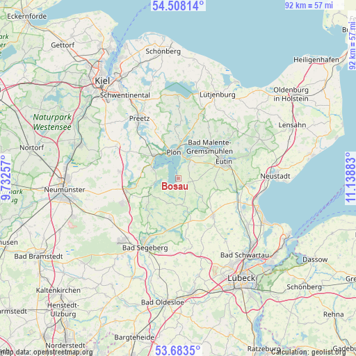
Bosau GPS coordinates[2]
54° 5' 52.332" North, 10° 26' 8.52" East
| Map corner | latitude | longitude |
|---|---|---|
| Upper-left | 54.50814°, | 9.73257° |
| Center: | 54.09787°, | 10.4357° |
| Lower-right: | 53.6835°, | 11.13883° |
| Map W x H: | 91.7×91.7 km | = 57×57mi |
| max Lat: | 55.01917° ⇑6.2% North |
| Bosau: | 54.09787° |
| min Lat: | ⇓93.8% South 47.40724° |
| min Long | Bosau | max Long |
| 5.92978° | 10.4357° | 14.98853° |
| W 57.9%⇐ | ⇒42.1% E |
Elevation
Elevation of Bosau is 47 m = 154 ft, and this is 202.1 m = 663 ft below average elevation for this country.
| Max E: |
1256 m = 4121 ft | 79.9% |
| Avg. | 249.1 m = 817 ft | |
| Bosau | 47 m = 154 ft | |
Min E: |
-5 m = -16 ft | 20.1% |
See also: Germany elevation on elevation.city.
Geographical zone
Bosau is located in North temperate zone (between Tropic of Cancer and the Arctic Circle). Distance of this North polar circle is 1386.1 km =861.3 mi to North.| Distance of | km | miles | from Bosau |
|---|---|---|---|
| North Pole | 3991.9 | 2480.5 | to North |
| Arctic Circle | 1386.1 | 861.3 | to North |
| Tropic Cancer | 3409.2 | 2118.4 | to South |
| Equator | 6015.1 | 3737.6 | to South |


Nearby cities:
15 places around Bosau: (largest is in red/bold)
• Ascheberg
8.3 km =5.2 mi,  314°
314°
• Bösdorf
6.6 km =4.1 mi,  28°
28°
• Damsdorf
8.5 km =5.3 mi,  245°
245°
• Dersau
7 km =4.3 mi,  288°
288°
• Dörnick
8.9 km =5.5 mi,  329°
329°
• Glasau
7.5 km =4.7 mi,  135°
135°
• Nehms
10.1 km =6.3 mi,  206°
206°
• Nehmten
2.3 km =1.4 mi,  275°
275°
• Plön
7.2 km =4.5 mi,  353°
353°
• Rathjensdorf
9.5 km =5.9 mi,  359°
359°
• Seedorf
5.5 km =3.4 mi,  193°
193°
• Stocksee
6.2 km =3.9 mi,  261°
261°
• Tensfeld
9.8 km =6.1 mi,  231°
231°
• Travenhorst
9.1 km =5.7 mi,  174°
174°
• Wittmoldt
8.9 km =5.5 mi, 329°
Sources, notices
• [Note1] Compared only with cities in Germany existing in our database
• [Src1] Map data: © OpenStreetMap contributors (CC-BY-SA)
• [Src2] Other city data from geonames.org with taken over terms of usage.
• [Src3] Geographical zone / Annual Mean Temperature by Robert A. Rohde @ Wikipedia
