Erwitte geodata
Erwitte (North Rhine-Westphalia) is a populated place; located in Germany in Europe/Berlin (GMT+2) time zone. With population of 16,081 people, there are 994 cities with bigger population in this country. Compared to other cities in Germany, 67.8% of cities are located further ↓South; 72.5% of cities are located further →East and 68% of cities have higher elevation than Erwitte. Note1
Administrative division(s):
- Level 1: North Rhine-Westphalia
- Level 2: Regierungsbezirk Arnsberg
- Level 3: Kreis Soest
- Level 4: Erwitte


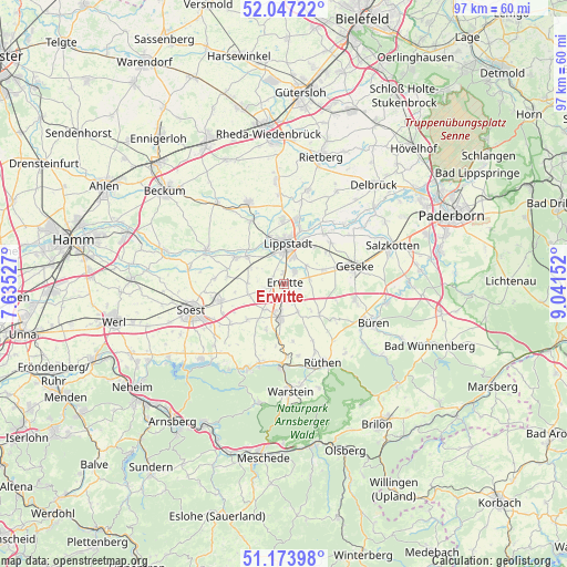
Erwitte GPS coordinates[2]
51° 36' 45.72" North, 8° 20' 18.24" East
| Map corner | latitude | longitude |
|---|---|---|
| Upper-left | 52.04722°, | 7.63527° |
| Center: | 51.6127°, | 8.3384° |
| Lower-right: | 51.17398°, | 9.04152° |
| Map W x H: | 97.1×97.1 km | = 60.3×60.3mi |
| max Lat: | 55.01917° ⇑32.2% North |
| Erwitte: | 51.6127° |
| min Lat: | ⇓67.8% South 47.40724° |
| min Long | Erwitte | max Long |
| 5.92978° | 8.3384° | 14.98853° |
| W 27.5%⇐ | ⇒72.5% E |
Elevation
Elevation of Erwitte is 102 m = 335 ft, and this is 147.1 m = 483 ft below average elevation for this country.
| Max E: |
1256 m = 4121 ft | 68% |
| Avg. | 249.1 m = 817 ft | |
| Erwitte | 102 m = 335 ft | |
Min E: |
-5 m = -16 ft | 32% |
See also: Germany elevation on elevation.city.
Geographical zone
Erwitte is located in North temperate zone (between Tropic of Cancer and the Arctic Circle). Distance of this North polar circle is 1662.4 km =1033 mi to North.| Distance of | km | miles | from Erwitte |
|---|---|---|---|
| North Pole | 4268.3 | 2652.2 | to North |
| Arctic Circle | 1662.4 | 1033 | to North |
| Tropic Cancer | 3132.9 | 1946.7 | to South |
| Equator | 5738.8 | 3565.9 | to South |


Nearby cities:
15 places around Erwitte: (largest is in red/bold)
• Anröchte
5.1 km =3.2 mi,  183°
183°
• Bad Sassendorf
12.3 km =7.6 mi,  254°
254°
• Büren
16.7 km =10.4 mi,  114°
114°
• Delbrück
22.9 km =14.2 mi,  42°
42°
• Geseke
12.3 km =7.6 mi,  75°
75°
• Langenberg
17.8 km =11.1 mi,  355°
355°
• Lippstadt
6.8 km =4.2 mi,  3°
3°
• Möhnesee
18.9 km =11.7 mi,  228°
228°
• Rietberg
22.7 km =14.1 mi,  15°
15°
• Rüthen
15.1 km =9.4 mi,  153°
153°
• Salzkotten
19.3 km =12 mi,  70°
70°
• Soest
16.6 km =10.3 mi,  255°
255°
• Wadersloh
14.7 km =9.1 mi,  335°
335°
• Warstein
18.7 km =11.6 mi, 177°
• Welver
25.7 km =16 mi,  270°
270°
Sources, notices
• [Note1] Compared only with cities in Germany existing in our database
• [Src1] Map data: © OpenStreetMap contributors (CC-BY-SA)
• [Src2] Other city data from geonames.org with taken over terms of usage.
• [Src3] Geographical zone / Annual Mean Temperature by Robert A. Rohde @ Wikipedia
