Geseke geodata
Geseke (North Rhine-Westphalia) is a populated place; located in Germany in Europe/Berlin (GMT+2) time zone. With population of 20,602 people, there are 746 cities with bigger population in this country. Compared to other cities in Germany, 68.2% of cities are located further ↓South; 71% of cities are located further →East and 67.8% of cities have higher elevation than Geseke. Note1
Administrative division(s):
- Level 1: North Rhine-Westphalia
- Level 2: Regierungsbezirk Arnsberg
- Level 3: Kreis Soest
- Level 4: Geseke


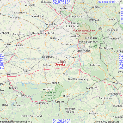
Geseke GPS coordinates[2]
51° 38' 27.276" North, 8° 30' 39.24" East
| Map corner | latitude | longitude |
|---|---|---|
| Upper-left | 52.07516°, | 7.80777° |
| Center: | 51.64091°, | 8.5109° |
| Lower-right: | 51.20246°, | 9.21402° |
| Map W x H: | 97×97 km | = 60.3×60.3mi |
| max Lat: | 55.01917° ⇑31.8% North |
| Geseke: | 51.64091° |
| min Lat: | ⇓68.2% South 47.40724° |
| min Long | Geseke | max Long |
| 5.92978° | 8.5109° | 14.98853° |
| W 29%⇐ | ⇒71% E |
Elevation
Elevation of Geseke is 103 m = 338 ft, and this is 146.1 m = 479 ft below average elevation for this country.
| Max E: |
1256 m = 4121 ft | 67.8% |
| Avg. | 249.1 m = 817 ft | |
| Geseke | 103 m = 338 ft | |
Min E: |
-5 m = -16 ft | 32.2% |
See also: Germany elevation on elevation.city.
Geographical zone
Geseke is located in North temperate zone (between Tropic of Cancer and the Arctic Circle). Distance of this North polar circle is 1659.2 km =1031 mi to North.| Distance of | km | miles | from Geseke |
|---|---|---|---|
| North Pole | 4265.1 | 2650.2 | to North |
| Arctic Circle | 1659.2 | 1031 | to North |
| Tropic Cancer | 3136 | 1948.6 | to South |
| Equator | 5741.9 | 3567.9 | to South |


Nearby cities:
15 places around Geseke: (largest is in red/bold)
• Anröchte
14.8 km =9.2 mi,  236°
236°
• Bad Sassendorf
24.6 km =15.3 mi,  254°
254°
• Büren
10.5 km =6.5 mi,  161°
161°
• Delbrück
14.2 km =8.8 mi,  14°
14°
• Erwitte
12.3 km =7.6 mi,  255°
255°
• Hövelhof
21.8 km =13.5 mi,  26°
26°
• Langenberg
19.7 km =12.2 mi,  317°
317°
• Lippstadt
12 km =7.5 mi,  287°
287°
• Paderborn
18.9 km =11.7 mi,  62°
62°
• Rietberg
19.6 km =12.2 mi,  343°
343°
• Rüthen
17.5 km =10.9 mi,  197°
197°
• Salzkotten
7.1 km =4.4 mi, 61°
• Wadersloh
20.7 km =12.9 mi,  299°
299°
• Warstein
24.5 km =15.2 mi,  207°
207°
• Wünnenberg
18.7 km =11.6 mi,  135°
135°
Sources, notices
• [Note1] Compared only with cities in Germany existing in our database
• [Src1] Map data: © OpenStreetMap contributors (CC-BY-SA)
• [Src2] Other city data from geonames.org with taken over terms of usage.
• [Src3] Geographical zone / Annual Mean Temperature by Robert A. Rohde @ Wikipedia
