Langenberg geodata
Langenberg (North Rhine-Westphalia) is a seat of a fourth-order administrative division; located in Germany in Europe/Berlin (GMT+2) time zone. With population of 8,207 people, there are 1925 cities with bigger population in this country. Compared to other cities in Germany, 69.7% of cities are located further ↓South; 72.7% of cities are located further →East and 70.9% of cities have higher elevation than Langenberg. Note1
Administrative division(s):
- Level 1: North Rhine-Westphalia
- Level 2: Regierungsbezirk Detmold
- Level 3: Kreis Gütersloh
- Level 4: Langenberg


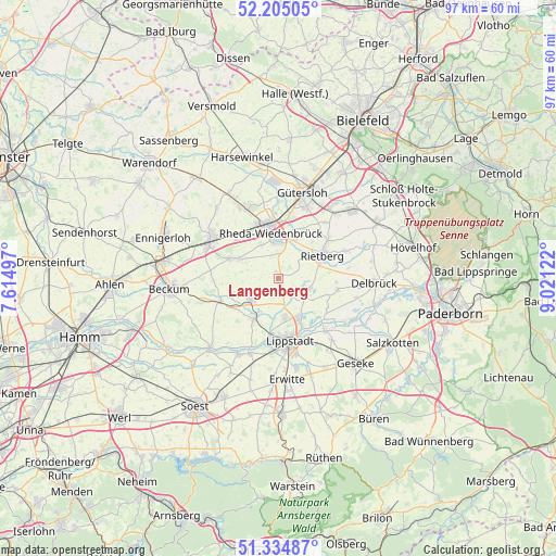
Langenberg GPS coordinates[2]
51° 46' 19.416" North, 8° 19' 5.124" East
| Map corner | latitude | longitude |
|---|---|---|
| Upper-left | 52.20505°, | 7.61497° |
| Center: | 51.77206°, | 8.31809° |
| Lower-right: | 51.33487°, | 9.02122° |
| Map W x H: | 96.8×96.8 km | = 60.1×60.1mi |
| max Lat: | 55.01917° ⇑30.3% North |
| Langenberg: | 51.77206° |
| min Lat: | ⇓69.7% South 47.40724° |
| min Long | Langenberg | max Long |
| 5.92978° | 8.31809° | 14.98853° |
| W 27.3%⇐ | ⇒72.7% E |
Elevation
Elevation of Langenberg is 86 m = 282 ft, and this is 163.1 m = 535 ft below average elevation for this country.
| Max E: |
1256 m = 4121 ft | 70.9% |
| Avg. | 249.1 m = 817 ft | |
| Langenberg | 86 m = 282 ft | |
Min E: |
-5 m = -16 ft | 29.1% |
See also: Germany elevation on elevation.city.
Geographical zone
Langenberg is located in North temperate zone (between Tropic of Cancer and the Arctic Circle). Distance of this North polar circle is 1644.7 km =1022 mi to North.| Distance of | km | miles | from Langenberg |
|---|---|---|---|
| North Pole | 4250.5 | 2641.1 | to North |
| Arctic Circle | 1644.7 | 1022 | to North |
| Tropic Cancer | 3150.6 | 1957.7 | to South |
| Equator | 5756.5 | 3576.9 | to South |


Nearby cities:
15 places around Langenberg: (largest is in red/bold)
• Beckum
19.2 km =11.9 mi,  264°
264°
• Beelen
22.5 km =14 mi,  320°
320°
• Delbrück
16.8 km =10.4 mi,  92°
92°
• Ennigerloh
21.1 km =13.1 mi,  290°
290°
• Erwitte
17.8 km =11.1 mi,  175°
175°
• Geseke
19.7 km =12.2 mi,  137°
137°
• Gütersloh
15.6 km =9.7 mi,  15°
15°
• Harsewinkel
22 km =13.7 mi,  343°
343°
• Lippstadt
11.1 km =6.9 mi,  170°
170°
• Oelde
13.3 km =8.3 mi,  298°
298°
• Rheda-Wiedenbrück
8.7 km =5.4 mi,  351°
351°
• Rietberg
8.6 km =5.3 mi,  61°
61°
• Salzkotten
22.5 km =14 mi,  119°
119°
• Verl
18.4 km =11.4 mi,  47°
47°
• Wadersloh
6.4 km =4 mi,  227°
227°
Sources, notices
• [Note1] Compared only with cities in Germany existing in our database
• [Src1] Map data: © OpenStreetMap contributors (CC-BY-SA)
• [Src2] Other city data from geonames.org with taken over terms of usage.
• [Src3] Geographical zone / Annual Mean Temperature by Robert A. Rohde @ Wikipedia
