Embsen geodata
Embsen (Lower Saxony) is a seat of a fourth-order administrative division; located in Germany in Europe/Berlin (GMT+2) time zone. With population of 2,496 people, there are 4445 cities with bigger population in this country. Compared to other cities in Germany, 82.7% of cities are located further ↓South; 56.2% of cities are located further ←West and 79.9% of cities have higher elevation than Embsen. Note1


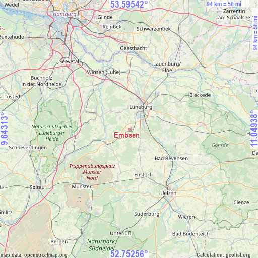
Embsen GPS coordinates[2]
53° 10' 33.816" North, 10° 20' 46.5" East
| Map corner | latitude | longitude |
|---|---|---|
| Upper-left | 53.59542°, | 9.64313° |
| Center: | 53.17606°, | 10.34625° |
| Lower-right: | 52.75256°, | 11.04938° |
| Map W x H: | 93.7×93.7 km | = 58.2×58.2mi |
| max Lat: | 55.01917° ⇑17.3% North |
| Embsen: | 53.17606° |
| min Lat: | ⇓82.7% South 47.40724° |
| min Long | Embsen | max Long |
| 5.92978° | 10.34625° | 14.98853° |
| W 56.2%⇐ | ⇒43.8% E |
Elevation
Elevation of Embsen is 47 m = 154 ft, and this is 202.1 m = 663 ft below average elevation for this country.
| Max E: |
1256 m = 4121 ft | 79.9% |
| Avg. | 249.1 m = 817 ft | |
| Embsen | 47 m = 154 ft | |
Min E: |
-5 m = -16 ft | 20.1% |
See also: Germany elevation on elevation.city.
Geographical zone
Embsen is located in North temperate zone (between Tropic of Cancer and the Arctic Circle). Distance of this North polar circle is 1488.6 km =925 mi to North.| Distance of | km | miles | from Embsen |
|---|---|---|---|
| North Pole | 4094.4 | 2544.1 | to North |
| Arctic Circle | 1488.6 | 925 | to North |
| Tropic Cancer | 3306.7 | 2054.7 | to South |
| Equator | 5912.6 | 3673.9 | to South |


Nearby cities:
15 places around Embsen: (largest is in red/bold)
• Amelinghausen
10.6 km =6.6 mi,  236°
236°
• Barnstedt
4.9 km =3 mi,  164°
164°
• Betzendorf
4.8 km =3 mi,  207°
207°
• Bienenbüttel
10.1 km =6.3 mi,  112°
112°
• Deutsch Evern
6.4 km =4 mi,  65°
65°
• Kirchgellersen
7.1 km =4.4 mi,  334°
334°
• Lüneburg
9.5 km =5.9 mi,  28°
28°
• Melbeck
3.7 km =2.3 mi,  77°
77°
• Oldendorf
9.1 km =5.7 mi,  255°
255°
• Rehlingen
11.4 km =7.1 mi,  226°
226°
• Reppenstedt
8.2 km =5.1 mi,  1°
1°
• Südergellersen
5.5 km =3.4 mi, 325°
• Vögelsen
11 km =6.8 mi, 2°
• Wendisch Evern
9.2 km =5.7 mi,  60°
60°
• Westergellersen
9 km =5.6 mi,  314°
314°
Sources, notices
• [Note1] Compared only with cities in Germany existing in our database
• [Src1] Map data: © OpenStreetMap contributors (CC-BY-SA)
• [Src2] Other city data from geonames.org with taken over terms of usage.
• [Src3] Geographical zone / Annual Mean Temperature by Robert A. Rohde @ Wikipedia
