Betzendorf geodata
Betzendorf (Lower Saxony) is a seat of a fourth-order administrative division; located in Germany in Europe/Berlin (GMT+2) time zone. With population of 1,141 people, there are 6730 cities with bigger population in this country. Compared to other cities in Germany, 82.5% of cities are located further ↓South; 55.6% of cities are located further ←West and 70.2% of cities have higher elevation than Betzendorf. Note1


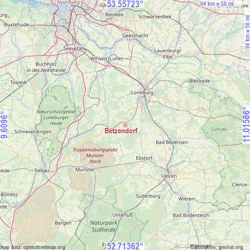
Betzendorf GPS coordinates[2]
53° 8' 15" North, 10° 18' 45.828" East
| Map corner | latitude | longitude |
|---|---|---|
| Upper-left | 53.55723°, | 9.6096° |
| Center: | 53.1375°, | 10.31273° |
| Lower-right: | 52.71362°, | 11.01586° |
| Map W x H: | 93.8×93.8 km | = 58.3×58.3mi |
| max Lat: | 55.01917° ⇑17.5% North |
| Betzendorf: | 53.1375° |
| min Lat: | ⇓82.5% South 47.40724° |
| min Long | Betzendorf | max Long |
| 5.92978° | 10.31273° | 14.98853° |
| W 55.6%⇐ | ⇒44.4% E |
Elevation
Elevation of Betzendorf is 90 m = 295 ft, and this is 159.1 m = 522 ft below average elevation for this country.
| Max E: |
1256 m = 4121 ft | 70.2% |
| Avg. | 249.1 m = 817 ft | |
| Betzendorf | 90 m = 295 ft | |
Min E: |
-5 m = -16 ft | 29.8% |
See also: Germany elevation on elevation.city.
Geographical zone
Betzendorf is located in North temperate zone (between Tropic of Cancer and the Arctic Circle). Distance of this North polar circle is 1492.8 km =927.6 mi to North.| Distance of | km | miles | from Betzendorf |
|---|---|---|---|
| North Pole | 4098.7 | 2546.8 | to North |
| Arctic Circle | 1492.8 | 927.6 | to North |
| Tropic Cancer | 3302.4 | 2052 | to South |
| Equator | 5908.3 | 3671.2 | to South |


Nearby cities:
15 places around Betzendorf: (largest is in red/bold)
• Amelinghausen
6.8 km =4.2 mi,  257°
257°
• Barnstedt
3.6 km =2.2 mi,  97°
97°
• Bienenbüttel
11.6 km =7.2 mi,  87°
87°
• Deutsch Evern
10.6 km =6.6 mi,  49°
49°
• Embsen
4.8 km =3 mi,  27°
27°
• Hanstedt Eins
10.9 km =6.8 mi,  157°
157°
• Kirchgellersen
10.7 km =6.6 mi,  355°
355°
• Melbeck
7.7 km =4.8 mi, 48°
• Natendorf
12.3 km =7.6 mi,  121°
121°
• Oldendorf
6.9 km =4.3 mi,  287°
287°
• Rehlingen
7.1 km =4.4 mi,  240°
240°
• Soderstorf
11 km =6.8 mi,  273°
273°
• Südergellersen
8.8 km =5.5 mi,  354°
354°
• Westergellersen
11.4 km =7.1 mi,  338°
338°
• Wriedel
11.8 km =7.3 mi,  184°
184°
Sources, notices
• [Note1] Compared only with cities in Germany existing in our database
• [Src1] Map data: © OpenStreetMap contributors (CC-BY-SA)
• [Src2] Other city data from geonames.org with taken over terms of usage.
• [Src3] Geographical zone / Annual Mean Temperature by Robert A. Rohde @ Wikipedia
