Barnstedt geodata
Barnstedt (Lower Saxony) is a seat of a fourth-order administrative division; located in Germany in Europe/Berlin (GMT+2) time zone. With population of 806 people, there are 7871 cities with bigger population in this country. Compared to other cities in Germany, 82.4% of cities are located further ↓South; 56.6% of cities are located further ←West and 77.9% of cities have higher elevation than Barnstedt. Note1


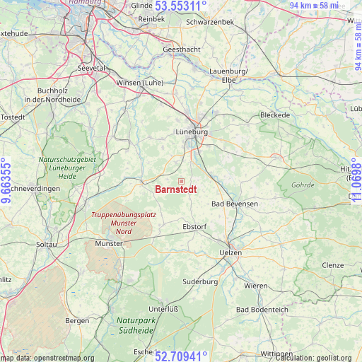
Barnstedt GPS coordinates[2]
53° 7' 59.988" North, 10° 22' 0.012" East
| Map corner | latitude | longitude |
|---|---|---|
| Upper-left | 53.55311°, | 9.66355° |
| Center: | 53.13333°, | 10.36667° |
| Lower-right: | 52.70941°, | 11.0698° |
| Map W x H: | 93.8×93.8 km | = 58.3×58.3mi |
| max Lat: | 55.01917° ⇑17.6% North |
| Barnstedt: | 53.13333° |
| min Lat: | ⇓82.4% South 47.40724° |
| min Long | Barnstedt | max Long |
| 5.92978° | 10.36667° | 14.98853° |
| W 56.6%⇐ | ⇒43.4% E |
Elevation
Elevation of Barnstedt is 53 m = 174 ft, and this is 196.1 m = 643 ft below average elevation for this country.
| Max E: |
1256 m = 4121 ft | 77.9% |
| Avg. | 249.1 m = 817 ft | |
| Barnstedt | 53 m = 174 ft | |
Min E: |
-5 m = -16 ft | 22.1% |
See also: Germany elevation on elevation.city.
Geographical zone
Barnstedt is located in North temperate zone (between Tropic of Cancer and the Arctic Circle). Distance of this North polar circle is 1493.3 km =927.9 mi to North.| Distance of | km | miles | from Barnstedt |
|---|---|---|---|
| North Pole | 4099.2 | 2547.1 | to North |
| Arctic Circle | 1493.3 | 927.9 | to North |
| Tropic Cancer | 3302 | 2051.8 | to South |
| Equator | 5907.9 | 3671 | to South |


Nearby cities:
15 places around Barnstedt: (largest is in red/bold)
• Amelinghausen
10.3 km =6.4 mi,  264°
264°
• Betzendorf
3.6 km =2.2 mi,  277°
277°
• Bienenbüttel
8.1 km =5 mi,  83°
83°
• Deutsch Evern
8.6 km =5.3 mi,  30°
30°
• Ebstorf
12.2 km =7.6 mi,  163°
163°
• Embsen
4.9 km =3 mi,  344°
344°
• Hanstedt Eins
9.7 km =6 mi,  176°
176°
• Jelmstorf
11 km =6.8 mi,  108°
108°
• Kirchgellersen
12 km =7.5 mi, 338°
• Melbeck
6 km =3.7 mi,  21°
21°
• Natendorf
9.1 km =5.7 mi,  130°
130°
• Oldendorf
10.5 km =6.5 mi, 283°
• Rehlingen
10.2 km =6.3 mi,  252°
252°
• Südergellersen
10.3 km =6.4 mi,  334°
334°
• Wendisch Evern
11.4 km =7.1 mi,  35°
35°
Sources, notices
• [Note1] Compared only with cities in Germany existing in our database
• [Src1] Map data: © OpenStreetMap contributors (CC-BY-SA)
• [Src2] Other city data from geonames.org with taken over terms of usage.
• [Src3] Geographical zone / Annual Mean Temperature by Robert A. Rohde @ Wikipedia
