Eggstätt geodata
Eggstätt (Bavaria) is a seat of a fourth-order administrative division; located in Germany in Europe/Berlin (GMT+2) time zone. With population of 2,809 people, there are 4158 cities with bigger population in this country. Compared to other cities in Germany, 96.3% of cities are located further ↑North; 86.7% of cities are located further ←West and 91.7% of cities have lower elevation than Eggstätt. Note1
Administrative division(s):
- Level 1: Bavaria
- Level 2: Upper Bavaria
- Level 3: Landkreis Rosenheim
- Level 4: Eggstätt


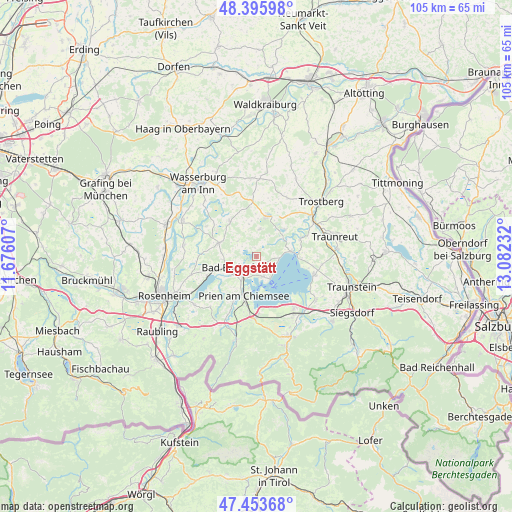
Eggstätt GPS coordinates[2]
47° 55' 37.128" North, 12° 22' 45.084" East
| Map corner | latitude | longitude |
|---|---|---|
| Upper-left | 48.39598°, | 11.67607° |
| Center: | 47.92698°, | 12.37919° |
| Lower-right: | 47.45368°, | 13.08232° |
| Map W x H: | 104.8×104.8 km | = 65.1×65.1mi |
| max Lat: | 55.01917° ⇑96.3% North |
| Eggstätt: | 47.92698° |
| min Lat: | ⇓3.7% South 47.40724° |
| min Long | Eggstätt | max Long |
| 5.92978° | 12.37919° | 14.98853° |
| W 86.7%⇐ | ⇒13.3% E |
Elevation
Elevation of Eggstätt is 538 m = 1765 ft, and this is 288.9 m = 948 ft above average elevation for this country.
| Max E: |
1256 m = 4121 ft | 8.3% |
| Eggstätt | 538 m 1765 ft | |
| Avg. | 249.1 m = 817 ft | |
Min E: |
-5 m = -16 ft | 91.7% |
See also: Germany elevation on elevation.city.
Geographical zone
Eggstätt is located in North temperate zone (between Tropic of Cancer and the Arctic Circle). Distance of this North polar circle is 2072.2 km =1287.6 mi to North.| Distance of | km | miles | from Eggstätt |
|---|---|---|---|
| North Pole | 4678.1 | 2906.8 | to North |
| Arctic Circle | 2072.2 | 1287.6 | to North |
| Tropic Cancer | 2723.1 | 1692.1 | to South |
| Equator | 5329 | 3311.3 | to South |


Nearby cities:
15 places around Eggstätt: (largest is in red/bold)
• Amerang
8.9 km =5.5 mi,  323°
323°
• Bad Endorf
6.4 km =4 mi,  251°
251°
• Bernau am Chiemsee
12.8 km =8 mi,  181°
181°
• Chieming
12.6 km =7.8 mi,  107°
107°
• Chiemsee
7.3 km =4.5 mi,  157°
157°
• Gstadt am Chiemsee
5.5 km =3.4 mi,  148°
148°
• Halfing
8.2 km =5.1 mi,  289°
289°
• Höslwang
4.8 km =3 mi,  308°
308°
• Obing
8.4 km =5.2 mi,  13°
13°
• Pittenhart
5.6 km =3.5 mi, 8°
• Prien am Chiemsee
8.3 km =5.2 mi,  197°
197°
• Rimsting
6 km =3.7 mi,  211°
211°
• Schonstett
11.5 km =7.1 mi,  303°
303°
• Seeon-Seebruck
7.9 km =4.9 mi,  55°
55°
• Söchtenau
11.2 km =7 mi,  272°
272°
Sources, notices
• [Note1] Compared only with cities in Germany existing in our database
• [Src1] Map data: © OpenStreetMap contributors (CC-BY-SA)
• [Src2] Other city data from geonames.org with taken over terms of usage.
• [Src3] Geographical zone / Annual Mean Temperature by Robert A. Rohde @ Wikipedia
