Schonstett geodata
Schonstett (Bavaria) is a seat of a fourth-order administrative division; located in Germany in Europe/Berlin (GMT+2) time zone. With population of 1,214 people, there are 6525 cities with bigger population in this country. Compared to other cities in Germany, 95.7% of cities are located further ↑North; 85.2% of cities are located further ←West and 86.9% of cities have lower elevation than Schonstett. Note1
Administrative division(s):
- Level 1: Bavaria
- Level 2: Upper Bavaria
- Level 3: Landkreis Rosenheim
- Level 4: Schonstett


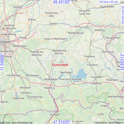
Schonstett GPS coordinates[2]
47° 58' 59.988" North, 12° 15' 0" East
| Map corner | latitude | longitude |
|---|---|---|
| Upper-left | 48.45182°, | 11.54688° |
| Center: | 47.98333°, | 12.25° |
| Lower-right: | 47.51055°, | 12.95313° |
| Map W x H: | 104.7×104.7 km | = 65.1×65.1mi |
| max Lat: | 55.01917° ⇑95.7% North |
| Schonstett: | 47.98333° |
| min Lat: | ⇓4.3% South 47.40724° |
| min Long | Schonstett | max Long |
| 5.92978° | 12.25° | 14.98853° |
| W 85.2%⇐ | ⇒14.8% E |
Elevation
Elevation of Schonstett is 485 m = 1591 ft, and this is 235.9 m = 774 ft above average elevation for this country.
| Max E: |
1256 m = 4121 ft | 13.1% |
| Schonstett | 485 m 1591 ft | |
| Avg. | 249.1 m = 817 ft | |
Min E: |
-5 m = -16 ft | 86.9% |
See also: Germany elevation on elevation.city.
Geographical zone
Schonstett is located in North temperate zone (between Tropic of Cancer and the Arctic Circle). Distance of this North polar circle is 2065.9 km =1283.7 mi to North.| Distance of | km | miles | from Schonstett |
|---|---|---|---|
| North Pole | 4671.8 | 2902.9 | to North |
| Arctic Circle | 2065.9 | 1283.7 | to North |
| Tropic Cancer | 2729.3 | 1695.9 | to South |
| Equator | 5335.2 | 3315.1 | to South |


Nearby cities:
15 places around Schonstett: (largest is in red/bold)
• Amerang
4.4 km =2.7 mi,  78°
78°
• Bad Endorf
9 km =5.6 mi,  156°
156°
• Breitbrunn
9.7 km =6 mi,  313°
313°
• Edling
10.3 km =6.4 mi,  321°
321°
• Eiselfing
6.5 km =4 mi,  355°
355°
• Griesstätt
5.5 km =3.4 mi,  282°
282°
• Halfing
4 km =2.5 mi,  151°
151°
• Höslwang
6.7 km =4.2 mi,  119°
119°
• Pittenhart
10.4 km =6.5 mi,  93°
93°
• Prutting
10.6 km =6.6 mi,  199°
199°
• Ramerberg
8.7 km =5.4 mi,  296°
296°
• Schönberg
8.9 km =5.5 mi,  17°
17°
• Söchtenau
6 km =3.7 mi,  194°
194°
• Vogtareuth
6.5 km =4 mi,  231°
231°
• Wasserburg am Inn
7.9 km =4.9 mi,  345°
345°
Sources, notices
• [Note1] Compared only with cities in Germany existing in our database
• [Src1] Map data: © OpenStreetMap contributors (CC-BY-SA)
• [Src2] Other city data from geonames.org with taken over terms of usage.
• [Src3] Geographical zone / Annual Mean Temperature by Robert A. Rohde @ Wikipedia
