Söchtenau geodata
Söchtenau (Bavaria) is a seat of a fourth-order administrative division; located in Germany in Europe/Berlin (GMT+2) time zone. With population of 2,616 people, there are 4316 cities with bigger population in this country. Compared to other cities in Germany, 96.3% of cities are located further ↑North; 85.1% of cities are located further ←West and 86.6% of cities have lower elevation than Söchtenau. Note1
Administrative division(s):
- Level 1: Bavaria
- Level 2: Upper Bavaria
- Level 3: Landkreis Rosenheim
- Level 4: Söchtenau


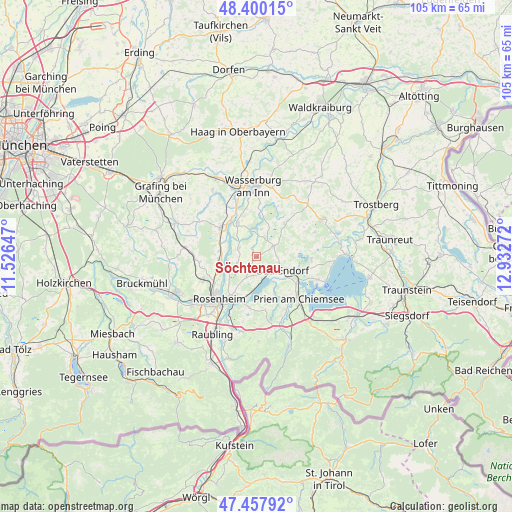
Söchtenau GPS coordinates[2]
47° 55' 52.248" North, 12° 13' 46.524" East
| Map corner | latitude | longitude |
|---|---|---|
| Upper-left | 48.40015°, | 11.52647° |
| Center: | 47.93118°, | 12.22959° |
| Lower-right: | 47.45792°, | 12.93272° |
| Map W x H: | 104.8×104.8 km | = 65.1×65.1mi |
| max Lat: | 55.01917° ⇑96.3% North |
| Söchtenau: | 47.93118° |
| min Lat: | ⇓3.7% South 47.40724° |
| min Long | Söchtenau | max Long |
| 5.92978° | 12.22959° | 14.98853° |
| W 85.1%⇐ | ⇒14.9% E |
Elevation
Elevation of Söchtenau is 482 m = 1581 ft, and this is 232.9 m = 764 ft above average elevation for this country.
| Max E: |
1256 m = 4121 ft | 13.4% |
| Söchtenau | 482 m 1581 ft | |
| Avg. | 249.1 m = 817 ft | |
Min E: |
-5 m = -16 ft | 86.6% |
See also: Germany elevation on elevation.city.
Geographical zone
Söchtenau is located in North temperate zone (between Tropic of Cancer and the Arctic Circle). Distance of this North polar circle is 2071.7 km =1287.3 mi to North.| Distance of | km | miles | from Söchtenau |
|---|---|---|---|
| North Pole | 4677.6 | 2906.5 | to North |
| Arctic Circle | 2071.7 | 1287.3 | to North |
| Tropic Cancer | 2723.5 | 1692.3 | to South |
| Equator | 5329.4 | 3311.5 | to South |


Nearby cities:
15 places around Söchtenau: (largest is in red/bold)
• Amerang
8.9 km =5.5 mi,  41°
41°
• Bad Endorf
5.7 km =3.5 mi,  115°
115°
• Eggstätt
11.2 km =7 mi,  92°
92°
• Griesstätt
8 km =5 mi,  330°
330°
• Halfing
4.1 km =2.5 mi,  55°
55°
• Höslwang
7.8 km =4.8 mi,  71°
71°
• Prutting
4.7 km =2.9 mi,  205°
205°
• Riedering
10.4 km =6.5 mi,  188°
188°
• Rimsting
9.8 km =6.1 mi, 124°
• Rosenheim
11.5 km =7.1 mi,  223°
223°
• Rott
10.6 km =6.6 mi,  263°
263°
• Schechen
7.9 km =4.9 mi,  268°
268°
• Schonstett
6 km =3.7 mi,  14°
14°
• Stephanskirchen
9.2 km =5.7 mi,  200°
200°
• Vogtareuth
4 km =2.5 mi,  295°
295°
Sources, notices
• [Note1] Compared only with cities in Germany existing in our database
• [Src1] Map data: © OpenStreetMap contributors (CC-BY-SA)
• [Src2] Other city data from geonames.org with taken over terms of usage.
• [Src3] Geographical zone / Annual Mean Temperature by Robert A. Rohde @ Wikipedia
