Chiemsee geodata
Chiemsee (Bavaria) is a seat of a fourth-order administrative division; located in Germany in Europe/Berlin (GMT+2) time zone. With population of 311 people, there are 10012 cities with bigger population in this country. Compared to other cities in Germany, 97% of cities are located further ↑North; 87.1% of cities are located further ←West and 90.1% of cities have lower elevation than Chiemsee. Note1
Administrative division(s):
- Level 1: Bavaria
- Level 2: Upper Bavaria
- Level 3: Landkreis Rosenheim
- Level 4: Chiemsee


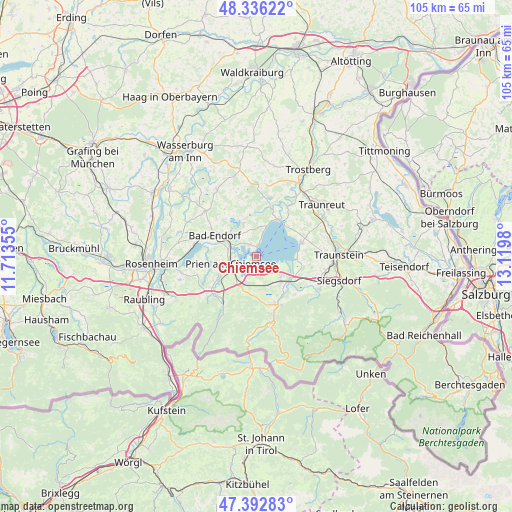
Chiemsee GPS coordinates[2]
47° 52' 0.012" North, 12° 25' 0.012" East
| Map corner | latitude | longitude |
|---|---|---|
| Upper-left | 48.33622°, | 11.71355° |
| Center: | 47.86667°, | 12.41667° |
| Lower-right: | 47.39283°, | 13.1198° |
| Map W x H: | 104.9×104.9 km | = 65.2×65.2mi |
| max Lat: | 55.01917° ⇑97% North |
| Chiemsee: | 47.86667° |
| min Lat: | ⇓3% South 47.40724° |
| min Long | Chiemsee | max Long |
| 5.92978° | 12.41667° | 14.98853° |
| W 87.1%⇐ | ⇒12.9% E |
Elevation
Elevation of Chiemsee is 515 m = 1690 ft, and this is 265.9 m = 872 ft above average elevation for this country.
| Max E: |
1256 m = 4121 ft | 9.9% |
| Chiemsee | 515 m 1690 ft | |
| Avg. | 249.1 m = 817 ft | |
Min E: |
-5 m = -16 ft | 90.1% |
See also: Germany elevation on elevation.city.
Geographical zone
Chiemsee is located in North temperate zone (between Tropic of Cancer and the Arctic Circle). Distance of this North polar circle is 2078.9 km =1291.8 mi to North.| Distance of | km | miles | from Chiemsee |
|---|---|---|---|
| North Pole | 4684.8 | 2911 | to North |
| Arctic Circle | 2078.9 | 1291.8 | to North |
| Tropic Cancer | 2716.4 | 1687.9 | to South |
| Equator | 5322.3 | 3307.1 | to South |


Nearby cities:
15 places around Chiemsee: (largest is in red/bold)
• Aschau im Chiemgau
12.2 km =7.6 mi,  215°
215°
• Bad Endorf
10 km =6.2 mi,  298°
298°
• Bernau am Chiemsee
6.8 km =4.2 mi,  206°
206°
• Chieming
9.6 km =6 mi,  72°
72°
• Eggstätt
7.3 km =4.5 mi,  337°
337°
• Frasdorf
12.1 km =7.5 mi,  234°
234°
• Grabenstätt
9.7 km =6 mi,  104°
104°
• Grassau
9.9 km =6.2 mi,  163°
163°
• Gstadt am Chiemsee
2 km =1.2 mi,  3°
3°
• Höslwang
11.7 km =7.3 mi,  326°
326°
• Prien am Chiemsee
5.4 km =3.4 mi,  257°
257°
• Rimsting
6.1 km =3.8 mi,  284°
284°
• Seeon-Seebruck
11.7 km =7.3 mi,  18°
18°
• Staudach-Egerndach
10.5 km =6.5 mi,  151°
151°
• Übersee
7.5 km =4.7 mi,  138°
138°
Sources, notices
• [Note1] Compared only with cities in Germany existing in our database
• [Src1] Map data: © OpenStreetMap contributors (CC-BY-SA)
• [Src2] Other city data from geonames.org with taken over terms of usage.
• [Src3] Geographical zone / Annual Mean Temperature by Robert A. Rohde @ Wikipedia
