Sulzemoos geodata
Sulzemoos (Bavaria) is a seat of a fourth-order administrative division; located in Germany in Europe/Berlin (GMT+2) time zone. With population of 2,507 people, there are 4433 cities with bigger population in this country. Compared to other cities in Germany, 91.3% of cities are located further ↑North; 70.9% of cities are located further ←West and 89.2% of cities have lower elevation than Sulzemoos. Note1
Administrative division(s):
- Level 1: Bavaria
- Level 2: Upper Bavaria
- Level 3: Landkreis Dachau
- Level 4: Sulzemoos


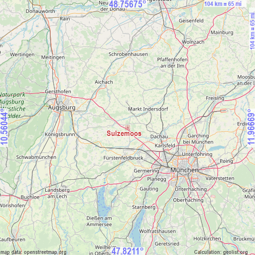
Sulzemoos GPS coordinates[2]
48° 17' 27.852" North, 11° 15' 48.816" East
| Map corner | latitude | longitude |
|---|---|---|
| Upper-left | 48.75675°, | 10.56044° |
| Center: | 48.29107°, | 11.26356° |
| Lower-right: | 47.8211°, | 11.96669° |
| Map W x H: | 104×104 km | = 64.6×64.6mi |
| max Lat: | 55.01917° ⇑91.3% North |
| Sulzemoos: | 48.29107° |
| min Lat: | ⇓8.7% South 47.40724° |
| min Long | Sulzemoos | max Long |
| 5.92978° | 11.26356° | 14.98853° |
| W 70.9%⇐ | ⇒29.1% E |
Elevation
Elevation of Sulzemoos is 505 m = 1657 ft, and this is 255.9 m = 840 ft above average elevation for this country.
| Max E: |
1256 m = 4121 ft | 10.8% |
| Sulzemoos | 505 m 1657 ft | |
| Avg. | 249.1 m = 817 ft | |
Min E: |
-5 m = -16 ft | 89.2% |
See also: Germany elevation on elevation.city.
Geographical zone
Sulzemoos is located in North temperate zone (between Tropic of Cancer and the Arctic Circle). Distance of this North polar circle is 2031.7 km =1262.4 mi to North.| Distance of | km | miles | from Sulzemoos |
|---|---|---|---|
| North Pole | 4637.6 | 2881.7 | to North |
| Arctic Circle | 2031.7 | 1262.4 | to North |
| Tropic Cancer | 2763.5 | 1717.2 | to South |
| Equator | 5369.5 | 3336.5 | to South |


Nearby cities:
15 places around Sulzemoos: (largest is in red/bold)
• Adelzhausen
11.8 km =7.3 mi,  308°
308°
• Altomünster
10.8 km =6.7 mi,  357°
357°
• Bergkirchen
8.4 km =5.2 mi,  116°
116°
• Egenhofen
7.2 km =4.5 mi,  263°
263°
• Emmering
12.1 km =7.5 mi,  173°
173°
• Erdweg
5.4 km =3.4 mi,  33°
33°
• Fürstenfeldbruck
12.5 km =7.8 mi,  183°
183°
• Maisach
8.3 km =5.2 mi, 178°
• Mammendorf
11.8 km =7.3 mi,  218°
218°
• Markt Indersdorf
11.5 km =7.1 mi,  47°
47°
• Oberschweinbach
9.9 km =6.2 mi,  233°
233°
• Odelzhausen
5.2 km =3.2 mi,  292°
292°
• Olching
11.4 km =7.1 mi,  152°
152°
• Pfaffenhofen
12.2 km =7.6 mi,  339°
339°
• Schwabhausen
7 km =4.3 mi,  78°
78°
Sources, notices
• [Note1] Compared only with cities in Germany existing in our database
• [Src1] Map data: © OpenStreetMap contributors (CC-BY-SA)
• [Src2] Other city data from geonames.org with taken over terms of usage.
• [Src3] Geographical zone / Annual Mean Temperature by Robert A. Rohde @ Wikipedia
