Bopfingen geodata
Bopfingen (Baden-Württemberg) is a populated place; located in Germany in Europe/Berlin (GMT+2) time zone. With population of 12,606 people, there are 1285 cities with bigger population in this country. Compared to other cities in Germany, 84.6% of cities are located further ↑North; 56.4% of cities are located further ←West and 84.3% of cities have lower elevation than Bopfingen. Note1
Administrative division(s):
- Level 1: Baden-Württemberg
- Level 2: Regierungsbezirk Stuttgart
- Level 3: Ostalbkreis
- Level 4: Bopfingen


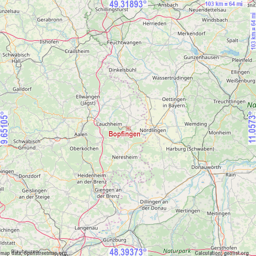
Bopfingen GPS coordinates[2]
48° 51' 30.492" North, 10° 21' 15.012" East
| Map corner | latitude | longitude |
|---|---|---|
| Upper-left | 49.31893°, | 9.65105° |
| Center: | 48.85847°, | 10.35417° |
| Lower-right: | 48.39373°, | 11.0573° |
| Map W x H: | 102.9×102.9 km | = 63.9×63.9mi |
| max Lat: | 55.01917° ⇑84.6% North |
| Bopfingen: | 48.85847° |
| min Lat: | ⇓15.4% South 47.40724° |
| min Long | Bopfingen | max Long |
| 5.92978° | 10.35417° | 14.98853° |
| W 56.4%⇐ | ⇒43.6% E |
Elevation
Elevation of Bopfingen is 463 m = 1519 ft, and this is 213.9 m = 702 ft above average elevation for this country.
| Max E: |
1256 m = 4121 ft | 15.7% |
| Bopfingen | 463 m 1519 ft | |
| Avg. | 249.1 m = 817 ft | |
Min E: |
-5 m = -16 ft | 84.3% |
See also: Germany elevation on elevation.city.
Geographical zone
Bopfingen is located in North temperate zone (between Tropic of Cancer and the Arctic Circle). Distance of this North polar circle is 1968.6 km =1223.2 mi to North.| Distance of | km | miles | from Bopfingen |
|---|---|---|---|
| North Pole | 4574.5 | 2842.5 | to North |
| Arctic Circle | 1968.6 | 1223.2 | to North |
| Tropic Cancer | 2826.6 | 1756.4 | to South |
| Equator | 5432.6 | 3375.7 | to South |


Nearby cities:
15 places around Bopfingen: (largest is in red/bold)
• Deiningen
15.6 km =9.7 mi,  86°
86°
• Ederheim
9.9 km =6.2 mi,  124°
124°
• Forheim
12.4 km =7.7 mi,  145°
145°
• Fremdingen
14.7 km =9.1 mi,  30°
30°
• Kirchheim am Ries
4.1 km =2.5 mi,  55°
55°
• Lauchheim
8.3 km =5.2 mi,  279°
279°
• Maihingen
13.1 km =8.1 mi,  54°
54°
• Marktoffingen
11.3 km =7 mi, 48°
• Neresheim
11.6 km =7.2 mi,  188°
188°
• Nördlingen
9.9 km =6.2 mi, 94°
• Reimlingen
12.8 km =8 mi,  111°
111°
• Tannhausen
13.4 km =8.3 mi,  2°
2°
• Unterschneidheim
8.4 km =5.2 mi,  6°
6°
• Wallerstein
9.5 km =5.9 mi,  70°
70°
• Westhausen
12.8 km =8 mi, 282°
Sources, notices
• [Note1] Compared only with cities in Germany existing in our database
• [Src1] Map data: © OpenStreetMap contributors (CC-BY-SA)
• [Src2] Other city data from geonames.org with taken over terms of usage.
• [Src3] Geographical zone / Annual Mean Temperature by Robert A. Rohde @ Wikipedia
