Durbach geodata
Durbach (Baden-Württemberg) is a seat of a fourth-order administrative division; located in Germany in Europe/Berlin (GMT+2) time zone. With population of 3,880 people, there are 3360 cities with bigger population in this country. Compared to other cities in Germany, 89.2% of cities are located further ↑North; 76.8% of cities are located further →East and 51.6% of cities have higher elevation than Durbach. Note1
Administrative division(s):
- Level 1: Baden-Württemberg
- Level 2: Freiburg Region
- Level 3: Ortenaukreis
- Level 4: Durbach


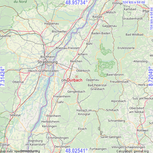
Durbach GPS coordinates[2]
48° 29' 36.672" North, 8° 1' 2.496" East
| Map corner | latitude | longitude |
|---|---|---|
| Upper-left | 48.95734°, | 7.31424° |
| Center: | 48.49352°, | 8.01736° |
| Lower-right: | 48.02541°, | 8.72049° |
| Map W x H: | 103.6×103.6 km | = 64.4×64.4mi |
| max Lat: | 55.01917° ⇑89.2% North |
| Durbach: | 48.49352° |
| min Lat: | ⇓10.8% South 47.40724° |
| min Long | Durbach | max Long |
| 5.92978° | 8.01736° | 14.98853° |
| W 23.2%⇐ | ⇒76.8% E |
Elevation
Elevation of Durbach is 214 m = 702 ft, and this is 35.1 m = 115 ft below average elevation for this country.
| Max E: |
1256 m = 4121 ft | 51.6% |
| Avg. | 249.1 m = 817 ft | |
| Durbach | 214 m = 702 ft | |
Min E: |
-5 m = -16 ft | 48.4% |
See also: Germany elevation on elevation.city.
Geographical zone
Durbach is located in North temperate zone (between Tropic of Cancer and the Arctic Circle). Distance of this North polar circle is 2009.2 km =1248.5 mi to North.| Distance of | km | miles | from Durbach |
|---|---|---|---|
| North Pole | 4615.1 | 2867.7 | to North |
| Arctic Circle | 2009.2 | 1248.5 | to North |
| Tropic Cancer | 2786.1 | 1731.2 | to South |
| Equator | 5392 | 3350.4 | to South |


Nearby cities:
15 places around Durbach: (largest is in red/bold)
• Appenweier
5.1 km =3.2 mi,  330°
330°
• Berghaupten
10 km =6.2 mi,  193°
193°
• Gengenbach
9.9 km =6.2 mi,  181°
181°
• Haslach
8.5 km =5.3 mi,  19°
19°
• Lautenbach
1.5 km =0.9 mi,  150°
150°
• Lautenbach
7.8 km =4.8 mi,  67°
67°
• Nordrach
11.5 km =7.1 mi, 154°
• Oberkirch
6.3 km =3.9 mi,  46°
46°
• Offenburg
5.8 km =3.6 mi,  247°
247°
• Ohlsbach
7 km =4.3 mi, 194°
• Oppenau
10.7 km =6.6 mi,  102°
102°
• Ortenberg
5.7 km =3.5 mi,  215°
215°
• Renchen
10.6 km =6.6 mi,  358°
358°
• Schutterwald
11 km =6.8 mi,  243°
243°
• Willstätt
10.5 km =6.5 mi,  299°
299°
Sources, notices
• [Note1] Compared only with cities in Germany existing in our database
• [Src1] Map data: © OpenStreetMap contributors (CC-BY-SA)
• [Src2] Other city data from geonames.org with taken over terms of usage.
• [Src3] Geographical zone / Annual Mean Temperature by Robert A. Rohde @ Wikipedia
