Gengenbach geodata
Gengenbach (Baden-Württemberg) is a populated place; located in Germany in Europe/Berlin (GMT+2) time zone. With population of 11,234 people, there are 1473 cities with bigger population in this country. Compared to other cities in Germany, 90.2% of cities are located further ↑North; 76.9% of cities are located further →East and 55.9% of cities have higher elevation than Gengenbach. Note1
Administrative division(s):
- Level 1: Baden-Württemberg
- Level 2: Freiburg Region
- Level 3: Ortenaukreis
- Level 4: Gengenbach


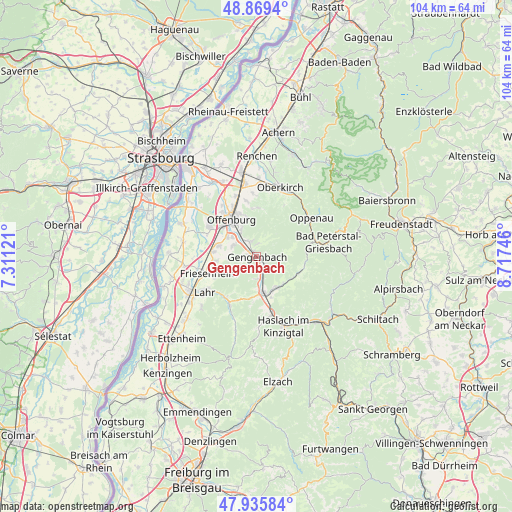
Gengenbach GPS coordinates[2]
48° 24' 17.136" North, 8° 0' 51.588" East
| Map corner | latitude | longitude |
|---|---|---|
| Upper-left | 48.8694°, | 7.31121° |
| Center: | 48.40476°, | 8.01433° |
| Lower-right: | 47.93584°, | 8.71746° |
| Map W x H: | 103.8×103.8 km | = 64.5×64.5mi |
| max Lat: | 55.01917° ⇑90.2% North |
| Gengenbach: | 48.40476° |
| min Lat: | ⇓9.8% South 47.40724° |
| min Long | Gengenbach | max Long |
| 5.92978° | 8.01433° | 14.98853° |
| W 23.1%⇐ | ⇒76.9% E |
Elevation
Elevation of Gengenbach is 182 m = 597 ft, and this is 67.1 m = 220 ft below average elevation for this country.
| Max E: |
1256 m = 4121 ft | 55.9% |
| Avg. | 249.1 m = 817 ft | |
| Gengenbach | 182 m = 597 ft | |
Min E: |
-5 m = -16 ft | 44.1% |
See also: Germany elevation on elevation.city.
Geographical zone
Gengenbach is located in North temperate zone (between Tropic of Cancer and the Arctic Circle). Distance of this North polar circle is 2019.1 km =1254.6 mi to North.| Distance of | km | miles | from Gengenbach |
|---|---|---|---|
| North Pole | 4625 | 2873.8 | to North |
| Arctic Circle | 2019.1 | 1254.6 | to North |
| Tropic Cancer | 2776.2 | 1725.1 | to South |
| Equator | 5382.1 | 3344.3 | to South |


Nearby cities:
15 places around Gengenbach: (largest is in red/bold)
• Berghaupten
2 km =1.2 mi,  273°
273°
• Biberach
8.1 km =5 mi,  169°
169°
• Durbach
9.9 km =6.2 mi,  1°
1°
• Friesenheim
10.6 km =6.6 mi,  246°
246°
• Hohberg
12.4 km =7.7 mi,  222°
222°
• Lahr
12.9 km =8 mi,  236°
236°
• Lautenbach
8.6 km =5.3 mi,  6°
6°
• Nordrach
5.1 km =3.2 mi,  95°
95°
• Oberharmersbach
8.9 km =5.5 mi,  112°
112°
• Offenburg
9.2 km =5.7 mi,  326°
326°
• Ohlsbach
3.4 km =2.1 mi, 333°
• Ortenberg
6.1 km =3.8 mi, 328°
• Schutterwald
10.9 km =6.8 mi,  297°
297°
• Seelbach
11.8 km =7.3 mi,  207°
207°
• Steinach
11.9 km =7.4 mi, 167°
Sources, notices
• [Note1] Compared only with cities in Germany existing in our database
• [Src1] Map data: © OpenStreetMap contributors (CC-BY-SA)
• [Src2] Other city data from geonames.org with taken over terms of usage.
• [Src3] Geographical zone / Annual Mean Temperature by Robert A. Rohde @ Wikipedia
