Ortenberg geodata
Ortenberg (Baden-Württemberg) is a seat of a fourth-order administrative division; located in Germany in Europe/Berlin (GMT+2) time zone. With population of 3,284 people, there are 3762 cities with bigger population in this country. Compared to other cities in Germany, 89.7% of cities are located further ↑North; 77.6% of cities are located further →East and 58.2% of cities have higher elevation than Ortenberg. Note1
Administrative division(s):
- Level 1: Baden-Württemberg
- Level 2: Freiburg Region
- Level 3: Ortenaukreis
- Level 4: Ortenberg


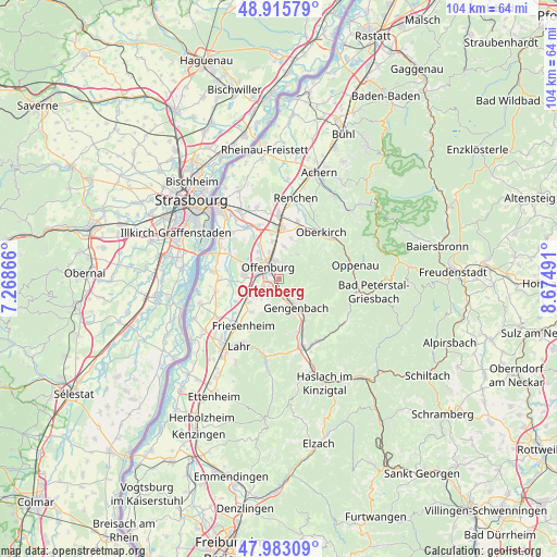
Ortenberg GPS coordinates[2]
48° 27' 5.688" North, 7° 58' 18.408" East
| Map corner | latitude | longitude |
|---|---|---|
| Upper-left | 48.91579°, | 7.26866° |
| Center: | 48.45158°, | 7.97178° |
| Lower-right: | 47.98309°, | 8.67491° |
| Map W x H: | 103.7×103.7 km | = 64.4×64.4mi |
| max Lat: | 55.01917° ⇑89.7% North |
| Ortenberg: | 48.45158° |
| min Lat: | ⇓10.3% South 47.40724° |
| min Long | Ortenberg | max Long |
| 5.92978° | 7.97178° | 14.98853° |
| W 22.4%⇐ | ⇒77.6% E |
Elevation
Elevation of Ortenberg is 166 m = 545 ft, and this is 83.1 m = 273 ft below average elevation for this country.
| Max E: |
1256 m = 4121 ft | 58.2% |
| Avg. | 249.1 m = 817 ft | |
| Ortenberg | 166 m = 545 ft | |
Min E: |
-5 m = -16 ft | 41.8% |
See also: Germany elevation on elevation.city.
Geographical zone
Ortenberg is located in North temperate zone (between Tropic of Cancer and the Arctic Circle). Distance of this North polar circle is 2013.9 km =1251.4 mi to North.| Distance of | km | miles | from Ortenberg |
|---|---|---|---|
| North Pole | 4619.8 | 2870.6 | to North |
| Arctic Circle | 2013.9 | 1251.4 | to North |
| Tropic Cancer | 2781.4 | 1728.3 | to South |
| Equator | 5387.3 | 3347.5 | to South |


Nearby cities:
15 places around Ortenberg: (largest is in red/bold)
• Appenweier
9.1 km =5.7 mi,  5°
5°
• Berghaupten
5.2 km =3.2 mi,  167°
167°
• Biberach
13.9 km =8.6 mi,  160°
160°
• Durbach
5.7 km =3.5 mi,  35°
35°
• Friesenheim
11.5 km =7.1 mi,  214°
214°
• Gengenbach
6.1 km =3.8 mi,  148°
148°
• Haslach
14.1 km =8.8 mi,  26°
26°
• Lautenbach
5.3 km =3.3 mi,  50°
50°
• Lautenbach
13.1 km =8.1 mi, 53°
• Nordrach
10 km =6.2 mi,  124°
124°
• Oberkirch
11.9 km =7.4 mi, 41°
• Offenburg
3.2 km =2 mi,  321°
321°
• Ohlsbach
2.7 km =1.7 mi,  142°
142°
• Schutterwald
6.5 km =4 mi,  268°
268°
• Willstätt
11.5 km =7.1 mi,  329°
329°
Sources, notices
• [Note1] Compared only with cities in Germany existing in our database
• [Src1] Map data: © OpenStreetMap contributors (CC-BY-SA)
• [Src2] Other city data from geonames.org with taken over terms of usage.
• [Src3] Geographical zone / Annual Mean Temperature by Robert A. Rohde @ Wikipedia
