Bethenhausen geodata
Bethenhausen (Thuringia) is a seat of a fourth-order administrative division; located in Germany in Europe/Berlin (GMT+2) time zone. With population of 270 people, there are 10165 cities with bigger population in this country. Compared to other cities in Germany, 56.7% of cities are located further ↓South; 84.6% of cities are located further ←West and 60% of cities have lower elevation than Bethenhausen. Note1


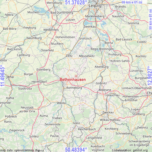
Bethenhausen GPS coordinates[2]
50° 55' 45.192" North, 12° 11' 58.452" East
| Map corner | latitude | longitude |
|---|---|---|
| Upper-left | 51.37028°, | 11.49645° |
| Center: | 50.92922°, | 12.19957° |
| Lower-right: | 50.48394°, | 12.9027° |
| Map W x H: | 98.6×98.5 km | = 61.3×61.2mi |
| max Lat: | 55.01917° ⇑43.3% North |
| Bethenhausen: | 50.92922° |
| min Lat: | ⇓56.7% South 47.40724° |
| min Long | Bethenhausen | max Long |
| 5.92978° | 12.19957° | 14.98853° |
| W 84.6%⇐ | ⇒15.4% E |
Elevation
Elevation of Bethenhausen is 290 m = 951 ft, and this is 40.9 m = 134 ft above average elevation for this country.
| Max E: |
1256 m = 4121 ft | 40% |
| Bethenhausen | 290 m 951 ft | |
| Avg. | 249.1 m = 817 ft | |
Min E: |
-5 m = -16 ft | 60% |
See also: Germany elevation on elevation.city.
Geographical zone
Bethenhausen is located in North temperate zone (between Tropic of Cancer and the Arctic Circle). Distance of this North polar circle is 1738.4 km =1080.2 mi to North.| Distance of | km | miles | from Bethenhausen |
|---|---|---|---|
| North Pole | 4344.3 | 2699.4 | to North |
| Arctic Circle | 1738.4 | 1080.2 | to North |
| Tropic Cancer | 3056.9 | 1899.5 | to South |
| Equator | 5662.8 | 3518.7 | to South |


Nearby cities:
15 places around Bethenhausen: (largest is in red/bold)
• Brahmenau
2.9 km =1.8 mi,  257°
257°
• Dobitschen
6.5 km =4 mi,  61°
61°
• Drogen
8.3 km =5.2 mi,  99°
99°
• Großenstein
3.2 km =2 mi,  179°
179°
• Hirschfeld
1.6 km =1 mi,  329°
329°
• Kayna
7.7 km =4.8 mi,  20°
20°
• Korbussen
4.7 km =2.9 mi,  204°
204°
• Lumpzig
5.2 km =3.2 mi, 63°
• Löbichau
6 km =3.7 mi,  131°
131°
• Pölzig
2.3 km =1.4 mi,  0°
0°
• Ronneburg
7.4 km =4.6 mi,  187°
187°
• Schellbach
7.9 km =4.9 mi,  312°
312°
• Schwaara
4.9 km =3 mi,  234°
234°
• Wildenbörten
6 km =3.7 mi, 103°
• Wittgendorf
5.4 km =3.4 mi,  356°
356°
Sources, notices
• [Note1] Compared only with cities in Germany existing in our database
• [Src1] Map data: © OpenStreetMap contributors (CC-BY-SA)
• [Src2] Other city data from geonames.org with taken over terms of usage.
• [Src3] Geographical zone / Annual Mean Temperature by Robert A. Rohde @ Wikipedia
