Dersau geodata
Dersau (Schleswig-Holstein) is a seat of a fourth-order administrative division; located in Germany in Europe/Berlin (GMT+2) time zone. With population of 936 people, there are 7401 cities with bigger population in this country. Compared to other cities in Germany, 94.2% of cities are located further ↓South; 56% of cities are located further ←West and 87.7% of cities have higher elevation than Dersau. Note1


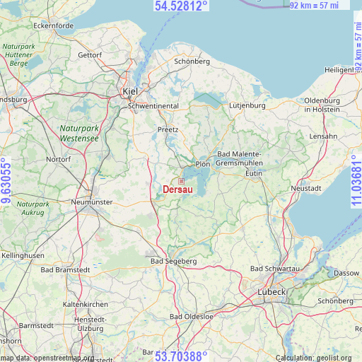
Dersau GPS coordinates[2]
54° 7' 4.98" North, 10° 20' 1.248" East
| Map corner | latitude | longitude |
|---|---|---|
| Upper-left | 54.52812°, | 9.63055° |
| Center: | 54.11805°, | 10.33368° |
| Lower-right: | 53.70388°, | 11.03681° |
| Map W x H: | 91.6×91.6 km | = 56.9×56.9mi |
| max Lat: | 55.01917° ⇑5.8% North |
| Dersau: | 54.11805° |
| min Lat: | ⇓94.2% South 47.40724° |
| min Long | Dersau | max Long |
| 5.92978° | 10.33368° | 14.98853° |
| W 56%⇐ | ⇒44% E |
Elevation
Elevation of Dersau is 28 m = 92 ft, and this is 221.1 m = 725 ft below average elevation for this country.
| Max E: |
1256 m = 4121 ft | 87.7% |
| Avg. | 249.1 m = 817 ft | |
| Dersau | 28 m = 92 ft | |
Min E: |
-5 m = -16 ft | 12.3% |
See also: Germany elevation on elevation.city.
Geographical zone
Dersau is located in North temperate zone (between Tropic of Cancer and the Arctic Circle). Distance of this North polar circle is 1383.8 km =859.9 mi to North.| Distance of | km | miles | from Dersau |
|---|---|---|---|
| North Pole | 3989.7 | 2479.1 | to North |
| Arctic Circle | 1383.8 | 859.9 | to North |
| Tropic Cancer | 3411.4 | 2119.7 | to South |
| Equator | 6017.4 | 3739 | to South |


Nearby cities:
15 places around Dersau: (largest is in red/bold)
• Ascheberg
3.7 km =2.3 mi,  12°
12°
• Belau
5.4 km =3.4 mi,  245°
245°
• Bosau
7 km =4.3 mi,  108°
108°
• Damsdorf
5.8 km =3.6 mi,  190°
190°
• Dörnick
5.8 km =3.6 mi,  21°
21°
• Kalübbe
3.3 km =2.1 mi,  267°
267°
• Nehmten
4.8 km =3 mi, 114°
• Plön
7.6 km =4.7 mi,  49°
49°
• Ruhwinkel
7.9 km =4.9 mi,  255°
255°
• Schmalensee
5.7 km =3.5 mi,  226°
226°
• Stocksee
3.2 km =2 mi,  170°
170°
• Stolpe
7.8 km =4.8 mi,  282°
282°
• Wahlstorf (Dorf)
7.2 km =4.5 mi,  339°
339°
• Wankendorf
8.4 km =5.2 mi, 265°
• Wittmoldt
5.8 km =3.6 mi, 21°
Sources, notices
• [Note1] Compared only with cities in Germany existing in our database
• [Src1] Map data: © OpenStreetMap contributors (CC-BY-SA)
• [Src2] Other city data from geonames.org with taken over terms of usage.
• [Src3] Geographical zone / Annual Mean Temperature by Robert A. Rohde @ Wikipedia
