Deisenhausen geodata
Deisenhausen (Bavaria) is a seat of a fourth-order administrative division; located in Germany in Europe/Berlin (GMT+2) time zone. With population of 1,533 people, there are 5816 cities with bigger population in this country. Compared to other cities in Germany, 91.9% of cities are located further ↑North; 55.9% of cities are located further ←West and 90.2% of cities have lower elevation than Deisenhausen. Note1
Administrative division(s):
- Level 1: Bavaria
- Level 2: Swabia
- Level 3: Landkreis Günzburg
- Level 4: Deisenhausen


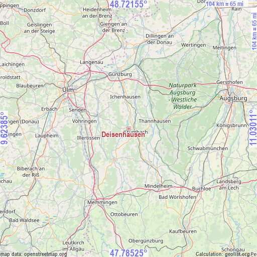
Deisenhausen GPS coordinates[2]
48° 15' 19.944" North, 10° 19' 37.128" East
| Map corner | latitude | longitude |
|---|---|---|
| Upper-left | 48.72155°, | 9.62385° |
| Center: | 48.25554°, | 10.32698° |
| Lower-right: | 47.78525°, | 11.03011° |
| Map W x H: | 104.1×104.1 km | = 64.7×64.7mi |
| max Lat: | 55.01917° ⇑91.9% North |
| Deisenhausen: | 48.25554° |
| min Lat: | ⇓8.1% South 47.40724° |
| min Long | Deisenhausen | max Long |
| 5.92978° | 10.32698° | 14.98853° |
| W 55.9%⇐ | ⇒44.1% E |
Elevation
Elevation of Deisenhausen is 517 m = 1696 ft, and this is 267.9 m = 879 ft above average elevation for this country.
| Max E: |
1256 m = 4121 ft | 9.8% |
| Deisenhausen | 517 m 1696 ft | |
| Avg. | 249.1 m = 817 ft | |
Min E: |
-5 m = -16 ft | 90.2% |
See also: Germany elevation on elevation.city.
Geographical zone
Deisenhausen is located in North temperate zone (between Tropic of Cancer and the Arctic Circle). Distance of this North polar circle is 2035.7 km =1264.9 mi to North.| Distance of | km | miles | from Deisenhausen |
|---|---|---|---|
| North Pole | 4641.5 | 2884.1 | to North |
| Arctic Circle | 2035.7 | 1264.9 | to North |
| Tropic Cancer | 2759.6 | 1714.7 | to South |
| Equator | 5365.5 | 3334 | to South |


Nearby cities:
15 places around Deisenhausen: (largest is in red/bold)
• Aletshausen
7.8 km =4.8 mi,  144°
144°
• Bayersried
9 km =5.6 mi,  86°
86°
• Breitenthal
2.8 km =1.7 mi,  225°
225°
• Buch
11.4 km =7.1 mi,  252°
252°
• Ebershausen
5.6 km =3.5 mi,  188°
188°
• Ellzee
9.4 km =5.8 mi,  356°
356°
• Kettershausen
9.2 km =5.7 mi,  209°
209°
• Kirchhaslach
11.8 km =7.3 mi, 186°
• Krumbach
3.1 km =1.9 mi,  119°
119°
• Münsterhausen
11.2 km =7 mi,  57°
57°
• Roggenburg
7.4 km =4.6 mi,  287°
287°
• Thannhausen
11 km =6.8 mi,  73°
73°
• Ursberg
8.9 km =5.5 mi,  83°
83°
• Waldstetten
10.6 km =6.6 mi,  346°
346°
• Waltenhausen
7.8 km =4.8 mi,  158°
158°
Sources, notices
• [Note1] Compared only with cities in Germany existing in our database
• [Src1] Map data: © OpenStreetMap contributors (CC-BY-SA)
• [Src2] Other city data from geonames.org with taken over terms of usage.
• [Src3] Geographical zone / Annual Mean Temperature by Robert A. Rohde @ Wikipedia
