Buch geodata
Buch (Bavaria) is a populated place; located in Germany in Europe/Berlin (GMT+2) time zone. With population of 3,709 people, there are 3469 cities with bigger population in this country. Compared to other cities in Germany, 92.3% of cities are located further ↑North; 53% of cities are located further ←West and 92.2% of cities have lower elevation than Buch. Note1
Administrative division(s):
- Level 1: Bavaria
- Level 2: Swabia
- Level 3: Landkreis Neu-Ulm
- Level 4: Buch, Markt


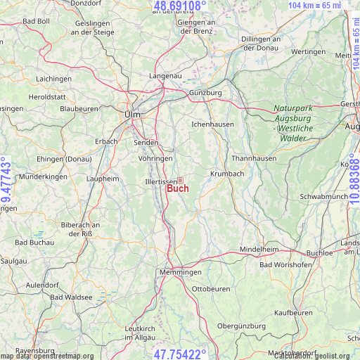
Buch GPS coordinates[2]
48° 13' 29.244" North, 10° 10' 49.98" East
| Map corner | latitude | longitude |
|---|---|---|
| Upper-left | 48.69108°, | 9.47743° |
| Center: | 48.22479°, | 10.18055° |
| Lower-right: | 47.75422°, | 10.88368° |
| Map W x H: | 104.2×104.2 km | = 64.7×64.7mi |
| max Lat: | 55.01917° ⇑92.3% North |
| Buch: | 48.22479° |
| min Lat: | ⇓7.7% South 47.40724° |
| min Long | Buch | max Long |
| 5.92978° | 10.18055° | 14.98853° |
| W 53%⇐ | ⇒47% E |
Elevation
Elevation of Buch is 545 m = 1788 ft, and this is 295.9 m = 971 ft above average elevation for this country.
| Max E: |
1256 m = 4121 ft | 7.8% |
| Buch | 545 m 1788 ft | |
| Avg. | 249.1 m = 817 ft | |
Min E: |
-5 m = -16 ft | 92.2% |
See also: Germany elevation on elevation.city.
Geographical zone
Buch is located in North temperate zone (between Tropic of Cancer and the Arctic Circle). Distance of this North polar circle is 2039.1 km =1267 mi to North.| Distance of | km | miles | from Buch |
|---|---|---|---|
| North Pole | 4645 | 2886.3 | to North |
| Arctic Circle | 2039.1 | 1267 | to North |
| Tropic Cancer | 2756.2 | 1712.6 | to South |
| Equator | 5362.1 | 3331.9 | to South |


Nearby cities:
15 places around Buch: (largest is in red/bold)
• Altenstadt
8.7 km =5.4 mi,  214°
214°
• Babenhausen
10.4 km =6.5 mi,  148°
148°
• Bellenberg
7.6 km =4.7 mi,  298°
298°
• Breitenthal
8.9 km =5.5 mi,  80°
80°
• Dietenheim
8.2 km =5.1 mi,  259°
259°
• Ebershausen
10.2 km =6.3 mi,  102°
102°
• Illerrieden
10.8 km =6.7 mi, 297°
• Illertissen
5.7 km =3.5 mi,  268°
268°
• Kettershausen
7.9 km =4.9 mi,  125°
125°
• Oberroth
5.5 km =3.4 mi,  173°
173°
• Osterberg
8.4 km =5.2 mi,  187°
187°
• Roggenburg
6.8 km =4.2 mi,  33°
33°
• Unterroth
3.3 km =2.1 mi, 192°
• Vöhringen
9.4 km =5.8 mi,  309°
309°
• Weißenhorn
9 km =5.6 mi,  350°
350°
Sources, notices
• [Note1] Compared only with cities in Germany existing in our database
• [Src1] Map data: © OpenStreetMap contributors (CC-BY-SA)
• [Src2] Other city data from geonames.org with taken over terms of usage.
• [Src3] Geographical zone / Annual Mean Temperature by Robert A. Rohde @ Wikipedia
