Selters geodata
Selters (Rheinland-Pfalz) is a populated place; located in Germany in Europe/Berlin (GMT+2) time zone. With population of 2,711 people, there are 4224 cities with bigger population in this country. Compared to other cities in Germany, 52.1% of cities are located further ↑North; 82% of cities are located further →East and 54.5% of cities have lower elevation than Selters. Note1
Administrative division(s):
- Level 1: Rheinland-Pfalz
- Level 3: Westerwaldkreis
- Level 4: Selters (Westerwald)


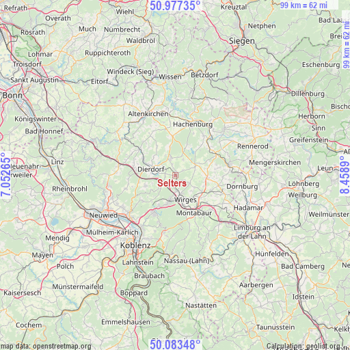
Selters GPS coordinates[2]
50° 31' 57.108" North, 7° 45' 20.772" East
| Map corner | latitude | longitude |
|---|---|---|
| Upper-left | 50.97735°, | 7.05265° |
| Center: | 50.53253°, | 7.75577° |
| Lower-right: | 50.08348°, | 8.4589° |
| Map W x H: | 99.4×99.4 km | = 61.8×61.8mi |
| max Lat: | 55.01917° ⇑52.1% North |
| Selters: | 50.53253° |
| min Lat: | ⇓47.9% South 47.40724° |
| min Long | Selters | max Long |
| 5.92978° | 7.75577° | 14.98853° |
| W 18%⇐ | ⇒82% E |
Elevation
Elevation of Selters is 255 m = 837 ft, and this is 5.9 m = 19 ft above average elevation for this country.
| Max E: |
1256 m = 4121 ft | 45.5% |
| Selters | 255 m 837 ft | |
| Avg. | 249.1 m = 817 ft | |
Min E: |
-5 m = -16 ft | 54.5% |
See also: Germany elevation on elevation.city.
Geographical zone
Selters is located in North temperate zone (between Tropic of Cancer and the Arctic Circle). Distance of this North polar circle is 1782.5 km =1107.6 mi to North.| Distance of | km | miles | from Selters |
|---|---|---|---|
| North Pole | 4388.4 | 2726.8 | to North |
| Arctic Circle | 1782.5 | 1107.6 | to North |
| Tropic Cancer | 3012.8 | 1872.1 | to South |
| Equator | 5618.7 | 3491.3 | to South |


Nearby cities:
15 places around Selters: (largest is in red/bold)
• Deesen
4.6 km =2.9 mi,  238°
238°
• Ellenhausen
2.8 km =1.7 mi,  230°
230°
• Ewighausen
5.1 km =3.2 mi,  86°
86°
• Goddert
2 km =1.2 mi,  341°
341°
• Hartenfels
5.1 km =3.2 mi,  25°
25°
• Helferskirchen
4.7 km =2.9 mi,  121°
121°
• Krümmel
2.3 km =1.4 mi,  283°
283°
• Marienrachdorf
3.4 km =2.1 mi,  305°
305°
• Maxsain
2.4 km =1.5 mi,  60°
60°
• Mogendorf
4.2 km =2.6 mi,  176°
176°
• Nordhofen
1.8 km =1.1 mi,  193°
193°
• Quirnbach
3.2 km =2 mi,  114°
114°
• Rückeroth
3.3 km =2.1 mi,  347°
347°
• Sessenhausen
3 km =1.9 mi,  258°
258°
• Vielbach
2.7 km =1.7 mi,  154°
154°
Sources, notices
• [Note1] Compared only with cities in Germany existing in our database
• [Src1] Map data: © OpenStreetMap contributors (CC-BY-SA)
• [Src2] Other city data from geonames.org with taken over terms of usage.
• [Src3] Geographical zone / Annual Mean Temperature by Robert A. Rohde @ Wikipedia
