Dahlenburg geodata
Dahlenburg (Lower Saxony) is a populated place; located in Germany in Europe/Berlin (GMT+2) time zone. With population of 3,465 people, there are 3639 cities with bigger population in this country. Compared to other cities in Germany, 82.8% of cities are located further ↓South; 63.1% of cities are located further ←West and 84.1% of cities have higher elevation than Dahlenburg. Note1
Administrative division(s):
- Level 1: Lower Saxony
- Level 3: Landkreis Lüneburg
- Level 4: Dahlenburg, Flecken


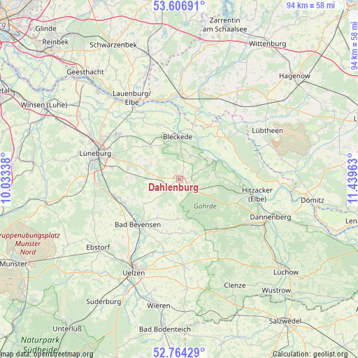
Dahlenburg GPS coordinates[2]
53° 11' 15.612" North, 10° 44' 11.4" East
| Map corner | latitude | longitude |
|---|---|---|
| Upper-left | 53.60691°, | 10.03338° |
| Center: | 53.18767°, | 10.7365° |
| Lower-right: | 52.76429°, | 11.43963° |
| Map W x H: | 93.7×93.7 km | = 58.2×58.2mi |
| max Lat: | 55.01917° ⇑17.2% North |
| Dahlenburg: | 53.18767° |
| min Lat: | ⇓82.8% South 47.40724° |
| min Long | Dahlenburg | max Long |
| 5.92978° | 10.7365° | 14.98853° |
| W 63.1%⇐ | ⇒36.9% E |
Elevation
Elevation of Dahlenburg is 37 m = 121 ft, and this is 212.1 m = 696 ft below average elevation for this country.
| Max E: |
1256 m = 4121 ft | 84.1% |
| Avg. | 249.1 m = 817 ft | |
| Dahlenburg | 37 m = 121 ft | |
Min E: |
-5 m = -16 ft | 15.9% |
See also: Germany elevation on elevation.city.
Geographical zone
Dahlenburg is located in North temperate zone (between Tropic of Cancer and the Arctic Circle). Distance of this North polar circle is 1487.3 km =924.2 mi to North.| Distance of | km | miles | from Dahlenburg |
|---|---|---|---|
| North Pole | 4093.1 | 2543.3 | to North |
| Arctic Circle | 1487.3 | 924.2 | to North |
| Tropic Cancer | 3308 | 2055.5 | to South |
| Equator | 5913.9 | 3674.7 | to South |


Nearby cities:
15 places around Dahlenburg: (largest is in red/bold)
• Altenmedingen
11 km =6.8 mi,  234°
234°
• Bleckede
11.3 km =7 mi,  359°
359°
• Boitze
4.3 km =2.7 mi,  167°
167°
• Dahlem
1.6 km =1 mi,  33°
33°
• Göhrde
10.6 km =6.6 mi,  113°
113°
• Himbergen
10.4 km =6.5 mi,  182°
182°
• Nahrendorf
5.4 km =3.4 mi, 106°
• Neetze
11.5 km =7.1 mi,  318°
318°
• Neu Darchau
10.9 km =6.8 mi,  65°
65°
• Reinstorf
12.1 km =7.5 mi,  295°
295°
• Römstedt
11.3 km =7 mi,  210°
210°
• Stoetze
13.8 km =8.6 mi, 166°
• Thomasburg
6.9 km =4.3 mi, 317°
• Tosterglope
6 km =3.7 mi, 65°
• Vastorf
12.8 km =8 mi,  275°
275°
Sources, notices
• [Note1] Compared only with cities in Germany existing in our database
• [Src1] Map data: © OpenStreetMap contributors (CC-BY-SA)
• [Src2] Other city data from geonames.org with taken over terms of usage.
• [Src3] Geographical zone / Annual Mean Temperature by Robert A. Rohde @ Wikipedia
