Nahrendorf geodata
Nahrendorf (Lower Saxony) is a seat of a fourth-order administrative division; located in Germany in Europe/Berlin (GMT+2) time zone. With population of 1,417 people, there are 6047 cities with bigger population in this country. Compared to other cities in Germany, 82.7% of cities are located further ↓South; 64.2% of cities are located further ←West and 73% of cities have higher elevation than Nahrendorf. Note1


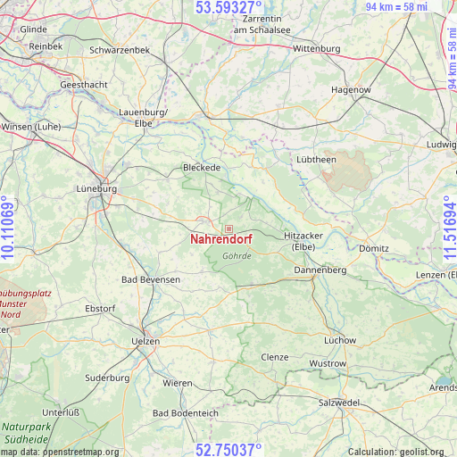
Nahrendorf GPS coordinates[2]
53° 10' 26.004" North, 10° 48' 49.716" East
| Map corner | latitude | longitude |
|---|---|---|
| Upper-left | 53.59327°, | 10.11069° |
| Center: | 53.17389°, | 10.81381° |
| Lower-right: | 52.75037°, | 11.51694° |
| Map W x H: | 93.7×93.7 km | = 58.2×58.2mi |
| max Lat: | 55.01917° ⇑17.3% North |
| Nahrendorf: | 53.17389° |
| min Lat: | ⇓82.7% South 47.40724° |
| min Long | Nahrendorf | max Long |
| 5.92978° | 10.81381° | 14.98853° |
| W 64.2%⇐ | ⇒35.8% E |
Elevation
Elevation of Nahrendorf is 72 m = 236 ft, and this is 177.1 m = 581 ft below average elevation for this country.
| Max E: |
1256 m = 4121 ft | 73% |
| Avg. | 249.1 m = 817 ft | |
| Nahrendorf | 72 m = 236 ft | |
Min E: |
-5 m = -16 ft | 27% |
See also: Germany elevation on elevation.city.
Geographical zone
Nahrendorf is located in North temperate zone (between Tropic of Cancer and the Arctic Circle). Distance of this North polar circle is 1488.8 km =925.1 mi to North.| Distance of | km | miles | from Nahrendorf |
|---|---|---|---|
| North Pole | 4094.7 | 2544.3 | to North |
| Arctic Circle | 1488.8 | 925.1 | to North |
| Tropic Cancer | 3306.5 | 2054.6 | to South |
| Equator | 5912.4 | 3673.8 | to South |


Nearby cities:
15 places around Nahrendorf: (largest is in red/bold)
• Altenmedingen
14.9 km =9.3 mi,  251°
251°
• Bleckede
13.9 km =8.6 mi,  337°
337°
• Boitze
5 km =3.1 mi,  238°
238°
• Dahlem
5.1 km =3.2 mi,  304°
304°
• Dahlenburg
5.4 km =3.4 mi,  286°
286°
• Göhrde
5.3 km =3.3 mi,  119°
119°
• Himbergen
10.5 km =6.5 mi,  212°
212°
• Hitzacker
15.5 km =9.6 mi,  98°
98°
• Neu Darchau
7.8 km =4.8 mi,  37°
37°
• Römstedt
13.7 km =8.5 mi,  233°
233°
• Stoetze
12.1 km =7.5 mi,  189°
189°
• Thomasburg
11.8 km =7.3 mi, 303°
• Tosterglope
4 km =2.5 mi,  5°
5°
• Weste
14.7 km =9.1 mi, 210°
• Zernien
12.6 km =7.8 mi,  158°
158°
Sources, notices
• [Note1] Compared only with cities in Germany existing in our database
• [Src1] Map data: © OpenStreetMap contributors (CC-BY-SA)
• [Src2] Other city data from geonames.org with taken over terms of usage.
• [Src3] Geographical zone / Annual Mean Temperature by Robert A. Rohde @ Wikipedia
