Boitze geodata
Boitze (Lower Saxony) is a seat of a fourth-order administrative division; located in Germany in Europe/Berlin (GMT+2) time zone. With population of 410 people, there are 9661 cities with bigger population in this country. Compared to other cities in Germany, 82.6% of cities are located further ↓South; 63.2% of cities are located further ←West and 78.3% of cities have higher elevation than Boitze. Note1


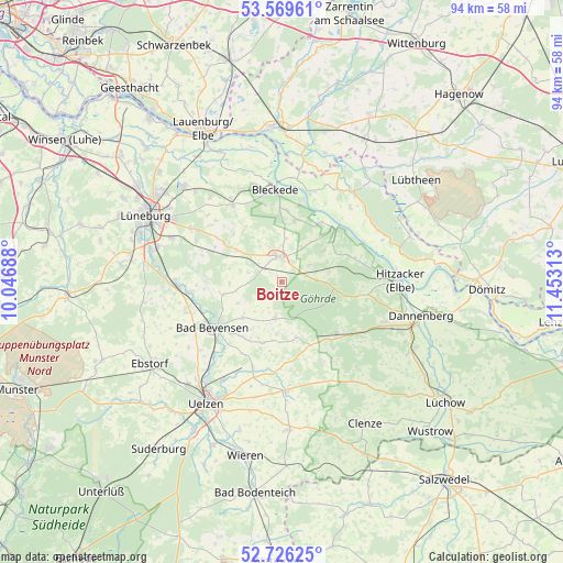
Boitze GPS coordinates[2]
53° 9' 0" North, 10° 45' 0" East
| Map corner | latitude | longitude |
|---|---|---|
| Upper-left | 53.56961°, | 10.04688° |
| Center: | 53.15°, | 10.75° |
| Lower-right: | 52.72625°, | 11.45313° |
| Map W x H: | 93.8×93.8 km | = 58.3×58.3mi |
| max Lat: | 55.01917° ⇑17.4% North |
| Boitze: | 53.15° |
| min Lat: | ⇓82.6% South 47.40724° |
| min Long | Boitze | max Long |
| 5.92978° | 10.75° | 14.98853° |
| W 63.2%⇐ | ⇒36.8% E |
Elevation
Elevation of Boitze is 52 m = 171 ft, and this is 197.1 m = 647 ft below average elevation for this country.
| Max E: |
1256 m = 4121 ft | 78.3% |
| Avg. | 249.1 m = 817 ft | |
| Boitze | 52 m = 171 ft | |
Min E: |
-5 m = -16 ft | 21.7% |
See also: Germany elevation on elevation.city.
Geographical zone
Boitze is located in North temperate zone (between Tropic of Cancer and the Arctic Circle). Distance of this North polar circle is 1491.4 km =926.7 mi to North.| Distance of | km | miles | from Boitze |
|---|---|---|---|
| North Pole | 4097.3 | 2545.9 | to North |
| Arctic Circle | 1491.4 | 926.7 | to North |
| Tropic Cancer | 3303.8 | 2052.9 | to South |
| Equator | 5909.7 | 3672.1 | to South |


Nearby cities:
15 places around Boitze: (largest is in red/bold)
• Altenmedingen
10.1 km =6.3 mi,  257°
257°
• Bad Bevensen
13.7 km =8.5 mi,  235°
235°
• Dahlem
5.6 km =3.5 mi,  0°
0°
• Dahlenburg
4.3 km =2.7 mi,  347°
347°
• Göhrde
8.9 km =5.5 mi,  90°
90°
• Himbergen
6.4 km =4 mi,  192°
192°
• Nahrendorf
5 km =3.1 mi,  58°
58°
• Neu Darchau
12.6 km =7.8 mi,  45°
45°
• Römstedt
8.7 km =5.4 mi,  230°
230°
• Stoetze
9.5 km =5.9 mi,  166°
166°
• Thomasburg
10.8 km =6.7 mi,  329°
329°
• Tosterglope
8.1 km =5 mi,  34°
34°
• Vastorf
14.6 km =9.1 mi,  291°
291°
• Weste
10.6 km =6.6 mi,  197°
197°
• Zernien
12.7 km =7.9 mi,  135°
135°
Sources, notices
• [Note1] Compared only with cities in Germany existing in our database
• [Src1] Map data: © OpenStreetMap contributors (CC-BY-SA)
• [Src2] Other city data from geonames.org with taken over terms of usage.
• [Src3] Geographical zone / Annual Mean Temperature by Robert A. Rohde @ Wikipedia
