Tosterglope geodata
Tosterglope (Lower Saxony) is a seat of a fourth-order administrative division; located in Germany in Europe/Berlin (GMT+2) time zone. With population of 628 people, there are 8665 cities with bigger population in this country. Compared to other cities in Germany, 82.9% of cities are located further ↓South; 64.4% of cities are located further ←West and 70.7% of cities have higher elevation than Tosterglope. Note1


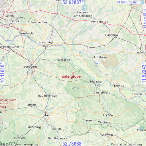
Tosterglope GPS coordinates[2]
53° 12' 35.424" North, 10° 49' 9.48" East
| Map corner | latitude | longitude |
|---|---|---|
| Upper-left | 53.62887°, | 10.11618° |
| Center: | 53.20984°, | 10.8193° |
| Lower-right: | 52.78668°, | 11.52243° |
| Map W x H: | 93.6×93.6 km | = 58.2×58.2mi |
| max Lat: | 55.01917° ⇑17.1% North |
| Tosterglope: | 53.20984° |
| min Lat: | ⇓82.9% South 47.40724° |
| min Long | Tosterglope | max Long |
| 5.92978° | 10.8193° | 14.98853° |
| W 64.4%⇐ | ⇒35.6% E |
Elevation
Elevation of Tosterglope is 87 m = 285 ft, and this is 162.1 m = 532 ft below average elevation for this country.
| Max E: |
1256 m = 4121 ft | 70.7% |
| Avg. | 249.1 m = 817 ft | |
| Tosterglope | 87 m = 285 ft | |
Min E: |
-5 m = -16 ft | 29.3% |
See also: Germany elevation on elevation.city.
Geographical zone
Tosterglope is located in North temperate zone (between Tropic of Cancer and the Arctic Circle). Distance of this North polar circle is 1484.8 km =922.6 mi to North.| Distance of | km | miles | from Tosterglope |
|---|---|---|---|
| North Pole | 4090.7 | 2541.8 | to North |
| Arctic Circle | 1484.8 | 922.6 | to North |
| Tropic Cancer | 3310.5 | 2057 | to South |
| Equator | 5916.4 | 3676.3 | to South |


Nearby cities:
15 places around Tosterglope: (largest is in red/bold)
• Besitz
15 km =9.3 mi,  10°
10°
• Bleckede
10.5 km =6.5 mi,  327°
327°
• Boitze
8.1 km =5 mi,  214°
214°
• Dahlem
4.7 km =2.9 mi,  256°
256°
• Dahlenburg
6 km =3.7 mi,  245°
245°
• Göhrde
7.9 km =4.9 mi,  147°
147°
• Himbergen
14.2 km =8.8 mi, 205°
• Hitzacker
16.3 km =10.1 mi,  113°
113°
• Nahrendorf
4 km =2.5 mi,  185°
185°
• Neetze
14.5 km =9 mi,  295°
295°
• Neu Darchau
4.9 km =3 mi,  64°
64°
• Römstedt
16.6 km =10.3 mi,  222°
222°
• Stoetze
16.1 km =10 mi, 188°
• Thomasburg
10.5 km =6.5 mi,  284°
284°
• Zernien
16.3 km =10.1 mi,  164°
164°
Sources, notices
• [Note1] Compared only with cities in Germany existing in our database
• [Src1] Map data: © OpenStreetMap contributors (CC-BY-SA)
• [Src2] Other city data from geonames.org with taken over terms of usage.
• [Src3] Geographical zone / Annual Mean Temperature by Robert A. Rohde @ Wikipedia
