Cuxhaven geodata
Cuxhaven (Lower Saxony) is a seat of a third-order administrative division; located in Germany in Europe/Berlin (GMT+2) time zone. With population of 52,677 people, there are 208 cities with bigger population in this country. Compared to other cities in Germany, 90.9% of cities are located further ↓South; 69.2% of cities are located further →East and 96.6% of cities have higher elevation than Cuxhaven. Note1


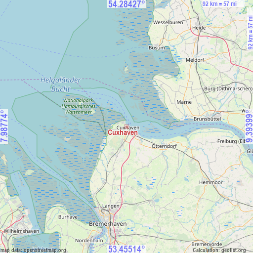
Cuxhaven GPS coordinates[2]
53° 52' 18.336" North, 8° 41' 27.132" East
| Map corner | latitude | longitude |
|---|---|---|
| Upper-left | 54.28427°, | 7.98774° |
| Center: | 53.87176°, | 8.69087° |
| Lower-right: | 53.45514°, | 9.39399° |
| Map W x H: | 92.2×92.2 km | = 57.3×57.3mi |
| max Lat: | 55.01917° ⇑9.1% North |
| Cuxhaven: | 53.87176° |
| min Lat: | ⇓90.9% South 47.40724° |
| min Long | Cuxhaven | max Long |
| 5.92978° | 8.69087° | 14.98853° |
| W 30.8%⇐ | ⇒69.2% E |
Elevation
Elevation of Cuxhaven is 5 m = 16 ft, and this is 244.1 m = 801 ft below average elevation for this country.
| Max E: |
1256 m = 4121 ft | 96.6% |
| Avg. | 249.1 m = 817 ft | |
| Cuxhaven | 5 m = 16 ft | |
Min E: |
-5 m = -16 ft | 3.4% |
See also: Cuxhaven elevation on elevation.city.
Geographical zone
Cuxhaven is located in North temperate zone (between Tropic of Cancer and the Arctic Circle). Distance of this North polar circle is 1411.2 km =876.9 mi to North.| Distance of | km | miles | from Cuxhaven |
|---|---|---|---|
| North Pole | 4017.1 | 2496.1 | to North |
| Arctic Circle | 1411.2 | 876.9 | to North |
| Tropic Cancer | 3384.1 | 2102.8 | to South |
| Equator | 5990 | 3722 | to South |


Nearby cities:
15 places around Cuxhaven: (largest is in red/bold)
• Belum
21.2 km =13.2 mi,  106°
106°
• Cappel
18 km =11.2 mi,  206°
206°
• Ihlienworth
21.4 km =13.3 mi,  136°
136°
• Kronprinzenkoog
20.9 km =13 mi,  59°
59°
• Marnerdeich
21 km =13 mi,  65°
65°
• Midlum
16.3 km =10.1 mi,  197°
197°
• Neuenkirchen
17 km =10.6 mi,  128°
128°
• Neufeld
21.6 km =13.4 mi,  81°
81°
• Neufelderkoog
18.3 km =11.4 mi, 80°
• Nordholz
11 km =6.8 mi, 207°
• Nordleda
15 km =9.3 mi, 141°
• Osterbruch
19.5 km =12.1 mi,  122°
122°
• Otterndorf
15.4 km =9.6 mi, 116°
• Steinau
14.5 km =9 mi, 207°
• Wanna
15.3 km =9.5 mi,  152°
152°
Sources, notices
• [Note1] Compared only with cities in Germany existing in our database
• [Src1] Map data: © OpenStreetMap contributors (CC-BY-SA)
• [Src2] Other city data from geonames.org with taken over terms of usage.
• [Src3] Geographical zone / Annual Mean Temperature by Robert A. Rohde @ Wikipedia
