Wanna geodata
Wanna (Lower Saxony) is a seat of a fourth-order administrative division; located in Germany in Europe/Berlin (GMT+2) time zone. With population of 2,419 people, there are 4536 cities with bigger population in this country. Compared to other cities in Germany, 89.3% of cities are located further ↓South; 68% of cities are located further →East and 99.9% of cities have higher elevation than Wanna. Note1


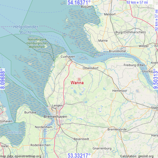
Wanna GPS coordinates[2]
53° 45' 0" North, 8° 48' 0" East
| Map corner | latitude | longitude |
|---|---|---|
| Upper-left | 54.16371°, | 8.09688° |
| Center: | 53.75°, | 8.8° |
| Lower-right: | 53.33217°, | 9.50313° |
| Map W x H: | 92.5×92.5 km | = 57.5×57.5mi |
| max Lat: | 55.01917° ⇑10.7% North |
| Wanna: | 53.75° |
| min Lat: | ⇓89.3% South 47.40724° |
| min Long | Wanna | max Long |
| 5.92978° | 8.8° | 14.98853° |
| W 32%⇐ | ⇒68% E |
Elevation
Elevation of Wanna is -3 m = -10 ft, and this is 252.1 m = 827 ft below average elevation for this country.
| Max E: |
1256 m = 4121 ft | 99.9% |
| Avg. | 249.1 m = 817 ft | |
| Wanna | -3 m = -10 ft | |
Min E: |
-5 m = -16 ft | 0.1% |
See also: Germany elevation on elevation.city.
Geographical zone
Wanna is located in North temperate zone (between Tropic of Cancer and the Arctic Circle). Distance of this North polar circle is 1424.7 km =885.3 mi to North.| Distance of | km | miles | from Wanna |
|---|---|---|---|
| North Pole | 4030.6 | 2504.5 | to North |
| Arctic Circle | 1424.7 | 885.3 | to North |
| Tropic Cancer | 3370.5 | 2094.3 | to South |
| Equator | 5976.4 | 3713.6 | to South |


Nearby cities:
15 places around Wanna: (largest is in red/bold)
• Belum
15.1 km =9.4 mi,  60°
60°
• Bülkau
11.7 km =7.3 mi,  92°
92°
• Cappel
15.3 km =9.5 mi,  260°
260°
• Flögeln
9.8 km =6.1 mi,  178°
178°
• Ihlienworth
7.9 km =4.9 mi,  103°
103°
• Midlum
12.2 km =7.6 mi, 260°
• Neuenkirchen
6.8 km =4.2 mi, 64°
• Nordholz
12.8 km =8 mi,  287°
287°
• Nordleda
2.9 km =1.8 mi,  49°
49°
• Odisheim
11.2 km =7 mi,  122°
122°
• Osterbruch
9.8 km =6.1 mi,  71°
71°
• Otterndorf
9.3 km =5.8 mi, 45°
• Steinau
9.2 km =5.7 mi,  143°
143°
• Steinau
13.8 km =8.6 mi,  272°
272°
• Stinstedt
15 km =9.3 mi,  131°
131°
Sources, notices
• [Note1] Compared only with cities in Germany existing in our database
• [Src1] Map data: © OpenStreetMap contributors (CC-BY-SA)
• [Src2] Other city data from geonames.org with taken over terms of usage.
• [Src3] Geographical zone / Annual Mean Temperature by Robert A. Rohde @ Wikipedia
