Midlum geodata
Midlum (Lower Saxony) is a seat of a fourth-order administrative division; located in Germany in Europe/Berlin (GMT+2) time zone. With population of 1,933 people, there are 5163 cities with bigger population in this country. Compared to other cities in Germany, 89.1% of cities are located further ↓South; 70% of cities are located further →East and 93.1% of cities have higher elevation than Midlum. Note1
Administrative division(s):
- Level 1: Lower Saxony
- Level 3: Landkreis Cuxhaven
- Level 4: Wurster Nordseeküste


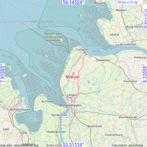
Midlum GPS coordinates[2]
53° 43' 52.86" North, 8° 37' 1.02" East
| Map corner | latitude | longitude |
|---|---|---|
| Upper-left | 54.14524°, | 7.91383° |
| Center: | 53.73135°, | 8.61695° |
| Lower-right: | 53.31334°, | 9.32008° |
| Map W x H: | 92.5×92.5 km | = 57.5×57.5mi |
| max Lat: | 55.01917° ⇑10.9% North |
| Midlum: | 53.73135° |
| min Lat: | ⇓89.1% South 47.40724° |
| min Long | Midlum | max Long |
| 5.92978° | 8.61695° | 14.98853° |
| W 30%⇐ | ⇒70% E |
Elevation
Elevation of Midlum is 13 m = 43 ft, and this is 236.1 m = 775 ft below average elevation for this country.
| Max E: |
1256 m = 4121 ft | 93.1% |
| Avg. | 249.1 m = 817 ft | |
| Midlum | 13 m = 43 ft | |
Min E: |
-5 m = -16 ft | 6.9% |
See also: Germany elevation on elevation.city.
Geographical zone
Midlum is located in North temperate zone (between Tropic of Cancer and the Arctic Circle). Distance of this North polar circle is 1426.8 km =886.6 mi to North.| Distance of | km | miles | from Midlum |
|---|---|---|---|
| North Pole | 4032.7 | 2505.8 | to North |
| Arctic Circle | 1426.8 | 886.6 | to North |
| Tropic Cancer | 3368.4 | 2093 | to South |
| Equator | 5974.4 | 3712.3 | to South |


Nearby cities:
15 places around Midlum: (largest is in red/bold)
• Cappel
3.1 km =1.9 mi,  259°
259°
• Cuxhaven
16.3 km =10.1 mi,  17°
17°
• Dorum
5.8 km =3.6 mi,  214°
214°
• Drangstedt
16 km =9.9 mi,  145°
145°
• Elmlohe
18.1 km =11.2 mi, 152°
• Flögeln
14.6 km =9.1 mi,  122°
122°
• Langen
14.1 km =8.8 mi,  185°
185°
• Misselwarden
9.1 km =5.7 mi,  226°
226°
• Mulsum
8.4 km =5.2 mi, 211°
• Nordholz
5.9 km =3.7 mi,  357°
357°
• Nordleda
14.8 km =9.2 mi,  74°
74°
• Padingbüttel
6.5 km =4 mi,  237°
237°
• Steinau
3.3 km =2.1 mi,  327°
327°
• Wanna
12.2 km =7.6 mi,  80°
80°
• Wremen
11.2 km =7 mi,  216°
216°
Sources, notices
• [Note1] Compared only with cities in Germany existing in our database
• [Src1] Map data: © OpenStreetMap contributors (CC-BY-SA)
• [Src2] Other city data from geonames.org with taken over terms of usage.
• [Src3] Geographical zone / Annual Mean Temperature by Robert A. Rohde @ Wikipedia
