Nordleda geodata
Nordleda (Lower Saxony) is a seat of a fourth-order administrative division; located in Germany in Europe/Berlin (GMT+2) time zone. With population of 1,184 people, there are 6607 cities with bigger population in this country. Compared to other cities in Germany, 89.5% of cities are located further ↓South; 67.5% of cities are located further →East and 99.8% of cities have higher elevation than Nordleda. Note1


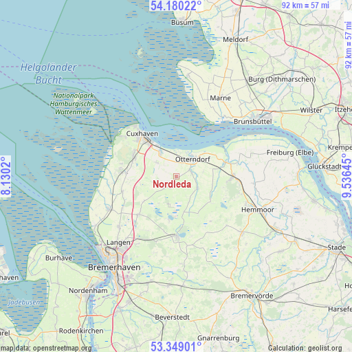
Nordleda GPS coordinates[2]
53° 46' 0.012" North, 8° 49' 59.988" East
| Map corner | latitude | longitude |
|---|---|---|
| Upper-left | 54.18022°, | 8.1302° |
| Center: | 53.76667°, | 8.83333° |
| Lower-right: | 53.34901°, | 9.53645° |
| Map W x H: | 92.4×92.4 km | = 57.4×57.4mi |
| max Lat: | 55.01917° ⇑10.5% North |
| Nordleda: | 53.76667° |
| min Lat: | ⇓89.5% South 47.40724° |
| min Long | Nordleda | max Long |
| 5.92978° | 8.83333° | 14.98853° |
| W 32.5%⇐ | ⇒67.5% E |
Elevation
Elevation of Nordleda is -2 m = -7 ft, and this is 251.1 m = 824 ft below average elevation for this country.
| Max E: |
1256 m = 4121 ft | 99.8% |
| Avg. | 249.1 m = 817 ft | |
| Nordleda | -2 m = -7 ft | |
Min E: |
-5 m = -16 ft | 0.2% |
See also: Germany elevation on elevation.city.
Geographical zone
Nordleda is located in North temperate zone (between Tropic of Cancer and the Arctic Circle). Distance of this North polar circle is 1422.9 km =884.1 mi to North.| Distance of | km | miles | from Nordleda |
|---|---|---|---|
| North Pole | 4028.8 | 2503.4 | to North |
| Arctic Circle | 1422.9 | 884.1 | to North |
| Tropic Cancer | 3372.4 | 2095.5 | to South |
| Equator | 5978.3 | 3714.7 | to South |


Nearby cities:
15 places around Nordleda: (largest is in red/bold)
• Belum
12.3 km =7.6 mi,  63°
63°
• Bülkau
9.8 km =6.1 mi,  103°
103°
• Cuxhaven
15 km =9.3 mi,  321°
321°
• Flögeln
11.8 km =7.3 mi,  189°
189°
• Ihlienworth
6.6 km =4.1 mi,  124°
124°
• Midlum
14.8 km =9.2 mi,  254°
254°
• Neuenkirchen
4.1 km =2.5 mi,  73°
73°
• Neuhaus an der Oste
13.7 km =8.5 mi, 74°
• Nordholz
14.6 km =9.1 mi,  277°
277°
• Odisheim
10.7 km =6.6 mi,  137°
137°
• Osterbruch
7.2 km =4.5 mi,  79°
79°
• Otterndorf
6.5 km =4 mi,  43°
43°
• Steinau
9.8 km =6.1 mi,  160°
160°
• Stinstedt
14.9 km =9.3 mi, 142°
• Wanna
2.9 km =1.8 mi,  229°
229°
Sources, notices
• [Note1] Compared only with cities in Germany existing in our database
• [Src1] Map data: © OpenStreetMap contributors (CC-BY-SA)
• [Src2] Other city data from geonames.org with taken over terms of usage.
• [Src3] Geographical zone / Annual Mean Temperature by Robert A. Rohde @ Wikipedia
