Nordholz geodata
Nordholz (Lower Saxony) is a seat of a fourth-order administrative division; located in Germany in Europe/Berlin (GMT+2) time zone. With population of 7,616 people, there are 2036 cities with bigger population in this country. Compared to other cities in Germany, 89.9% of cities are located further ↓South; 70% of cities are located further →East and 92.3% of cities have higher elevation than Nordholz. Note1
Administrative division(s):
- Level 1: Lower Saxony
- Level 3: Landkreis Cuxhaven
- Level 4: Wurster Nordseeküste


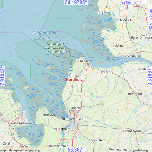
Nordholz GPS coordinates[2]
53° 47' 4.128" North, 8° 36' 48.744" East
| Map corner | latitude | longitude |
|---|---|---|
| Upper-left | 54.19785°, | 7.91042° |
| Center: | 53.78448°, | 8.61354° |
| Lower-right: | 53.367°, | 9.31667° |
| Map W x H: | 92.4×92.4 km | = 57.4×57.4mi |
| max Lat: | 55.01917° ⇑10.1% North |
| Nordholz: | 53.78448° |
| min Lat: | ⇓89.9% South 47.40724° |
| min Long | Nordholz | max Long |
| 5.92978° | 8.61354° | 14.98853° |
| W 30%⇐ | ⇒70% E |
Elevation
Elevation of Nordholz is 15 m = 49 ft, and this is 234.1 m = 768 ft below average elevation for this country.
| Max E: |
1256 m = 4121 ft | 92.3% |
| Avg. | 249.1 m = 817 ft | |
| Nordholz | 15 m = 49 ft | |
Min E: |
-5 m = -16 ft | 7.7% |
See also: Germany elevation on elevation.city.
Geographical zone
Nordholz is located in North temperate zone (between Tropic of Cancer and the Arctic Circle). Distance of this North polar circle is 1420.9 km =882.9 mi to North.| Distance of | km | miles | from Nordholz |
|---|---|---|---|
| North Pole | 4026.8 | 2502.1 | to North |
| Arctic Circle | 1420.9 | 882.9 | to North |
| Tropic Cancer | 3374.4 | 2096.8 | to South |
| Equator | 5980.3 | 3716 | to South |


Nearby cities:
15 places around Nordholz: (largest is in red/bold)
• Cappel
7 km =4.3 mi,  203°
203°
• Cuxhaven
11 km =6.8 mi,  27°
27°
• Dorum
11.2 km =7 mi, 195°
• Flögeln
18.6 km =11.6 mi,  137°
137°
• Langen
19.9 km =12.4 mi,  183°
183°
• Midlum
5.9 km =3.7 mi, 177°
• Misselwarden
13.7 km =8.5 mi,  207°
207°
• Mulsum
13.8 km =8.6 mi, 197°
• Neuenkirchen
18.4 km =11.4 mi,  92°
92°
• Nordleda
14.6 km =9.1 mi,  97°
97°
• Otterndorf
19.1 km =11.9 mi,  81°
81°
• Padingbüttel
10.8 km =6.7 mi, 209°
• Steinau
3.5 km =2.2 mi, 205°
• Wanna
12.8 km =8 mi,  107°
107°
• Wremen
16.3 km =10.1 mi, 203°
Sources, notices
• [Note1] Compared only with cities in Germany existing in our database
• [Src1] Map data: © OpenStreetMap contributors (CC-BY-SA)
• [Src2] Other city data from geonames.org with taken over terms of usage.
• [Src3] Geographical zone / Annual Mean Temperature by Robert A. Rohde @ Wikipedia
