Clausthal-Zellerfeld geodata
Clausthal-Zellerfeld (Lower Saxony) is a populated place; located in Germany in Europe/Berlin (GMT+2) time zone. With population of 15,345 people, there are 1040 cities with bigger population in this country. Compared to other cities in Germany, 70.1% of cities are located further ↓South; 56.1% of cities are located further ←West and 92.9% of cities have lower elevation than Clausthal-Zellerfeld. Note1
Administrative division(s):
- Level 1: Lower Saxony
- Level 3: Landkreis Goslar
- Level 4: Clausthal-Zellerfeld


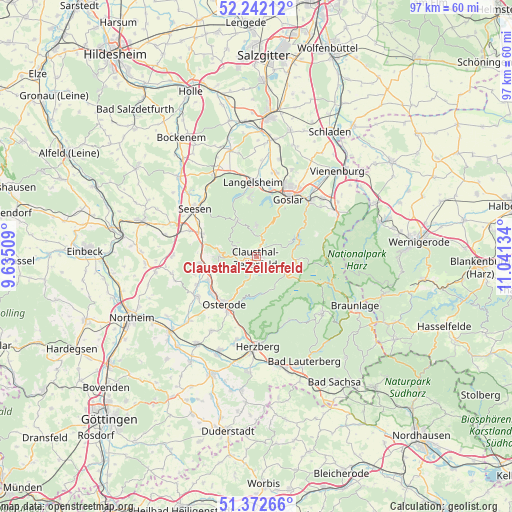
Clausthal-Zellerfeld GPS coordinates[2]
51° 48' 34.164" North, 10° 20' 17.556" East
| Map corner | latitude | longitude |
|---|---|---|
| Upper-left | 52.24212°, | 9.63509° |
| Center: | 51.80949°, | 10.33821° |
| Lower-right: | 51.37266°, | 11.04134° |
| Map W x H: | 96.7×96.7 km | = 60.1×60.1mi |
| max Lat: | 55.01917° ⇑29.9% North |
| Clausthal-Zellerfeld: | 51.80949° |
| min Lat: | ⇓70.1% South 47.40724° |
| min Long | Clausthal-Zelle | max Long |
| 5.92978° | 10.33821° | 14.98853° |
| W 56.1%⇐ | ⇒43.9% E |
Elevation
Elevation of Clausthal-Zellerfeld is 556 m = 1824 ft, and this is 306.9 m = 1007 ft above average elevation for this country.
| Max E: |
1256 m = 4121 ft | 7.1% |
| Clausthal-Zellerfeld | 556 m 1824 ft | |
| Avg. | 249.1 m = 817 ft | |
Min E: |
-5 m = -16 ft | 92.9% |
See also: Germany elevation on elevation.city.
Geographical zone
Clausthal-Zellerfeld is located in North temperate zone (between Tropic of Cancer and the Arctic Circle). Distance of this North polar circle is 1640.5 km =1019.4 mi to North.| Distance of | km | miles | from Clausthal-Zellerfeld |
|---|---|---|---|
| North Pole | 4246.4 | 2638.6 | to North |
| Arctic Circle | 1640.5 | 1019.4 | to North |
| Tropic Cancer | 3154.8 | 1960.3 | to South |
| Equator | 5760.7 | 3579.5 | to South |


Nearby cities:
15 places around Clausthal-Zellerfeld: (largest is in red/bold)
• Altenau
7.2 km =4.5 mi,  97°
97°
• Bad Grund
7 km =4.3 mi,  270°
270°
• Badenhausen
10.2 km =6.3 mi,  244°
244°
• Eisdorf am Harz
12.4 km =7.7 mi, 244°
• Gittelde
10.4 km =6.5 mi,  263°
263°
• Goslar
12.2 km =7.6 mi,  30°
30°
• Herzberg am Harz
17.1 km =10.6 mi,  179°
179°
• Hörden
16.1 km =10 mi,  193°
193°
• Langelsheim
14.3 km =8.9 mi,  358°
358°
• Osterode am Harz
11 km =6.8 mi,  213°
213°
• Sankt Andreasberg
16.6 km =10.3 mi,  131°
131°
• Schulenberg im Oberharz
7.1 km =4.4 mi,  67°
67°
• Seesen
14.2 km =8.8 mi,  309°
309°
• Wildemann
4.4 km =2.7 mi,  297°
297°
• Windhausen
9.1 km =5.7 mi,  252°
252°
Sources, notices
• [Note1] Compared only with cities in Germany existing in our database
• [Src1] Map data: © OpenStreetMap contributors (CC-BY-SA)
• [Src2] Other city data from geonames.org with taken over terms of usage.
• [Src3] Geographical zone / Annual Mean Temperature by Robert A. Rohde @ Wikipedia
