Altenau geodata
Altenau (Lower Saxony) is a populated place; located in Germany in Europe/Berlin (GMT+2) time zone. With population of 2,045 people, there are 5002 cities with bigger population in this country. Compared to other cities in Germany, 70% of cities are located further ↓South; 57.9% of cities are located further ←West and 89.9% of cities have lower elevation than Altenau. Note1
Administrative division(s):
- Level 1: Lower Saxony
- Level 3: Landkreis Goslar
- Level 4: Clausthal-Zellerfeld


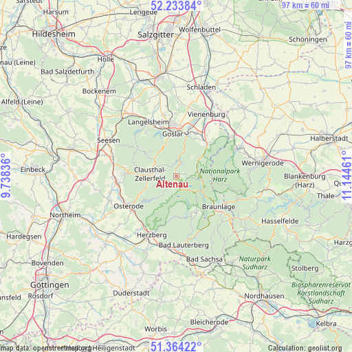
Altenau GPS coordinates[2]
51° 48' 4.068" North, 10° 26' 29.328" East
| Map corner | latitude | longitude |
|---|---|---|
| Upper-left | 52.23384°, | 9.73836° |
| Center: | 51.80113°, | 10.44148° |
| Lower-right: | 51.36422°, | 11.14461° |
| Map W x H: | 96.7×96.7 km | = 60.1×60.1mi |
| max Lat: | 55.01917° ⇑30% North |
| Altenau: | 51.80113° |
| min Lat: | ⇓70% South 47.40724° |
| min Long | Altenau | max Long |
| 5.92978° | 10.44148° | 14.98853° |
| W 57.9%⇐ | ⇒42.1% E |
Elevation
Elevation of Altenau is 513 m = 1683 ft, and this is 263.9 m = 866 ft above average elevation for this country.
| Max E: |
1256 m = 4121 ft | 10.1% |
| Altenau | 513 m 1683 ft | |
| Avg. | 249.1 m = 817 ft | |
Min E: |
-5 m = -16 ft | 89.9% |
See also: Germany elevation on elevation.city.
Geographical zone
Altenau is located in North temperate zone (between Tropic of Cancer and the Arctic Circle). Distance of this North polar circle is 1641.4 km =1019.9 mi to North.| Distance of | km | miles | from Altenau |
|---|---|---|---|
| North Pole | 4247.3 | 2639.1 | to North |
| Arctic Circle | 1641.4 | 1019.9 | to North |
| Tropic Cancer | 3153.8 | 1959.7 | to South |
| Equator | 5759.7 | 3578.9 | to South |


Nearby cities:
15 places around Altenau: (largest is in red/bold)
• Bad Grund
14.1 km =8.8 mi,  274°
274°
• Bad Harzburg
12.3 km =7.6 mi,  42°
42°
• Badenhausen
16.6 km =10.3 mi,  257°
257°
• Braunlage
14.3 km =8.9 mi,  125°
125°
• Clausthal-Zellerfeld
7.2 km =4.5 mi,  277°
277°
• Gittelde
17.4 km =10.8 mi, 269°
• Goslar
11.5 km =7.1 mi,  355°
355°
• Herzberg am Harz
17.7 km =11 mi,  203°
203°
• Langelsheim
16.9 km =10.5 mi,  333°
333°
• Osterode am Harz
15.5 km =9.6 mi,  237°
237°
• Sankt Andreasberg
11.4 km =7.1 mi,  152°
152°
• Schierke
15.7 km =9.8 mi,  105°
105°
• Schulenberg im Oberharz
3.6 km =2.2 mi,  351°
351°
• Wildemann
11.4 km =7.1 mi,  285°
285°
• Windhausen
15.9 km =9.9 mi, 263°
Sources, notices
• [Note1] Compared only with cities in Germany existing in our database
• [Src1] Map data: © OpenStreetMap contributors (CC-BY-SA)
• [Src2] Other city data from geonames.org with taken over terms of usage.
• [Src3] Geographical zone / Annual Mean Temperature by Robert A. Rohde @ Wikipedia
