Goslar geodata
Goslar (Lower Saxony) is a seat of a third-order administrative division; located in Germany in Europe/Berlin (GMT+2) time zone. With population of 43,560 people, there are 279 cities with bigger population in this country. Compared to other cities in Germany, 71.2% of cities are located further ↓South; 57.6% of cities are located further ←West and 56.7% of cities have lower elevation than Goslar. Note1


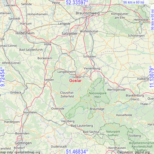
Goslar GPS coordinates[2]
51° 54' 15.3" North, 10° 25' 39.576" East
| Map corner | latitude | longitude |
|---|---|---|
| Upper-left | 52.33597°, | 9.72454° |
| Center: | 51.90425°, | 10.42766° |
| Lower-right: | 51.46834°, | 11.13079° |
| Map W x H: | 96.5×96.5 km | = 60×60mi |
| max Lat: | 55.01917° ⇑28.8% North |
| Goslar: | 51.90425° |
| min Lat: | ⇓71.2% South 47.40724° |
| min Long | Goslar | max Long |
| 5.92978° | 10.42766° | 14.98853° |
| W 57.6%⇐ | ⇒42.4% E |
Elevation
Elevation of Goslar is 270 m = 886 ft, and this is 20.9 m = 69 ft above average elevation for this country.
| Max E: |
1256 m = 4121 ft | 43.3% |
| Goslar | 270 m 886 ft | |
| Avg. | 249.1 m = 817 ft | |
Min E: |
-5 m = -16 ft | 56.7% |
See also: Goslar elevation on elevation.city.
Geographical zone
Goslar is located in North temperate zone (between Tropic of Cancer and the Arctic Circle). Distance of this North polar circle is 1630 km =1012.8 mi to North.| Distance of | km | miles | from Goslar |
|---|---|---|---|
| North Pole | 4235.9 | 2632.1 | to North |
| Arctic Circle | 1630 | 1012.8 | to North |
| Tropic Cancer | 3165.3 | 1966.8 | to South |
| Equator | 5771.2 | 3586.1 | to South |


Nearby cities:
15 places around Goslar: (largest is in red/bold)
• Abbenrode
13.8 km =8.6 mi,  78°
78°
• Alt Wallmoden
15.4 km =9.6 mi,  326°
326°
• Altenau
11.5 km =7.1 mi,  175°
175°
• Bad Harzburg
9.5 km =5.9 mi,  104°
104°
• Clausthal-Zellerfeld
12.2 km =7.6 mi,  210°
210°
• Gielde
15.4 km =9.6 mi,  17°
17°
• Hahausen
15.3 km =9.5 mi,  289°
289°
• Langelsheim
7.5 km =4.7 mi,  299°
299°
• Liebenburg
13.1 km =8.1 mi,  1°
1°
• Lutter am Barenberge
14.4 km =8.9 mi,  311°
311°
• Schladen
15.2 km =9.4 mi,  30°
30°
• Schulenberg im Oberharz
7.9 km =4.9 mi, 177°
• Vienenburg
10.8 km =6.7 mi,  60°
60°
• Wildemann
13.1 km =8.1 mi,  229°
229°
• Wülperode
14.5 km =9 mi,  53°
53°
Sources, notices
• [Note1] Compared only with cities in Germany existing in our database
• [Src1] Map data: © OpenStreetMap contributors (CC-BY-SA)
• [Src2] Other city data from geonames.org with taken over terms of usage.
• [Src3] Geographical zone / Annual Mean Temperature by Robert A. Rohde @ Wikipedia
