Schulenberg im Oberharz geodata
Schulenberg im Oberharz (Lower Saxony) is a seat of a fourth-order administrative division; located in Germany in Europe/Berlin (GMT+2) time zone. In our database, there are 11009 cities with bigger population. Compared to other cities in Germany, 70.3% of cities are located further ↓South; 57.7% of cities are located further ←West and 86.6% of cities have lower elevation than Schulenberg im Oberharz. Note1
Administrative division(s):
- Level 1: Lower Saxony
- Level 3: Landkreis Goslar
- Level 4: Clausthal-Zellerfeld
Current local time in Schulenberg im Oberharz:
03:50 PM, TuesdayDifference from your time zone: hours


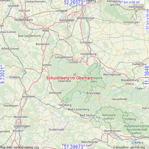
Schulenberg im Oberharz GPS coordinates[2]
51° 49' 59.988" North, 10° 25' 59.988" East
| Map corner | latitude | longitude |
|---|---|---|
| Upper-left | 52.26573°, | 9.73021° |
| Center: | 51.83333°, | 10.43333° |
| Lower-right: | 51.39673°, | 11.13646° |
| Map W x H: | 96.6×96.6 km | = 60×60mi |
| max Lat: | 55.01917° ⇑29.7% North |
| Schulenberg im Oberharz: | 51.83333° |
| min Lat: | ⇓70.3% South 47.40724° |
| min Long | Schulenberg im | max Long |
| 5.92978° | 10.43333° | 14.98853° |
| W 57.7%⇐ | ⇒42.3% E |
Elevation
Elevation of Schulenberg im Oberharz is 482 m = 1581 ft, and this is 232.9 m = 764 ft above average elevation for this country.
| Max E: |
1256 m = 4121 ft | 13.4% |
| Schulenberg im Oberharz | 482 m 1581 ft | |
| Avg. | 249.1 m = 817 ft | |
Min E: |
-5 m = -16 ft | 86.6% |
See also: Germany elevation on elevation.city.
Geographical zone
Schulenberg im Oberharz is located in North temperate zone (between Tropic of Cancer and the Arctic Circle). Distance of this North polar circle is 1637.8 km =1017.7 mi to North.| Distance of | km | miles | from Schulenberg im Oberharz |
|---|---|---|---|
| North Pole | 4243.7 | 2636.9 | to North |
| Arctic Circle | 1637.8 | 1017.7 | to North |
| Tropic Cancer | 3157.4 | 1961.9 | to South |
| Equator | 5763.3 | 3581.1 | to South |


Nearby cities:
15 places around Schulenberg im Oberharz: (largest is in red/bold)
• Abbenrode
16.9 km =10.5 mi,  51°
51°
• Altenau
3.6 km =2.2 mi,  171°
171°
• Bad Grund
13.7 km =8.5 mi,  259°
259°
• Bad Harzburg
10.4 km =6.5 mi,  58°
58°
• Badenhausen
17.2 km =10.7 mi,  245°
245°
• Braunlage
17 km =10.6 mi,  134°
134°
• Clausthal-Zellerfeld
7.1 km =4.4 mi, 247°
• Goslar
7.9 km =4.9 mi,  357°
357°
• Ilsenburg
17.2 km =10.7 mi,  77°
77°
• Langelsheim
13.5 km =8.4 mi,  329°
329°
• Osterode am Harz
17.3 km =10.7 mi,  226°
226°
• Sankt Andreasberg
14.9 km =9.3 mi,  156°
156°
• Vienenburg
16 km =9.9 mi,  34°
34°
• Wildemann
10.4 km =6.5 mi,  266°
266°
• Windhausen
16.1 km =10 mi, 250°
Sources, notices
• [Note1] Compared only with cities in Germany existing in our database
• [Src1] Map data: © OpenStreetMap contributors (CC-BY-SA)
• [Src2] Other city data from geonames.org with taken over terms of usage.
• [Src3] Geographical zone / Annual Mean Temperature by Robert A. Rohde @ Wikipedia
