Langelsheim geodata
Langelsheim (Lower Saxony) is a populated place; located in Germany in Europe/Berlin (GMT+2) time zone. With population of 13,169 people, there are 1217 cities with bigger population in this country. Compared to other cities in Germany, 71.5% of cities are located further ↓South; 56% of cities are located further ←West and 53.4% of cities have higher elevation than Langelsheim. Note1


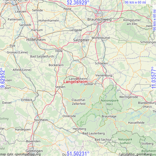
Langelsheim GPS coordinates[2]
51° 56' 16.404" North, 10° 19' 57.504" East
| Map corner | latitude | longitude |
|---|---|---|
| Upper-left | 52.36929°, | 9.62952° |
| Center: | 51.93789°, | 10.33264° |
| Lower-right: | 51.50231°, | 11.03577° |
| Map W x H: | 96.4×96.4 km | = 59.9×59.9mi |
| max Lat: | 55.01917° ⇑28.5% North |
| Langelsheim: | 51.93789° |
| min Lat: | ⇓71.5% South 47.40724° |
| min Long | Langelsheim | max Long |
| 5.92978° | 10.33264° | 14.98853° |
| W 56%⇐ | ⇒44% E |
Elevation
Elevation of Langelsheim is 201 m = 659 ft, and this is 48.1 m = 158 ft below average elevation for this country.
| Max E: |
1256 m = 4121 ft | 53.4% |
| Avg. | 249.1 m = 817 ft | |
| Langelsheim | 201 m = 659 ft | |
Min E: |
-5 m = -16 ft | 46.6% |
See also: Germany elevation on elevation.city.
Geographical zone
Langelsheim is located in North temperate zone (between Tropic of Cancer and the Arctic Circle). Distance of this North polar circle is 1626.2 km =1010.5 mi to North.| Distance of | km | miles | from Langelsheim |
|---|---|---|---|
| North Pole | 4232.1 | 2629.7 | to North |
| Arctic Circle | 1626.2 | 1010.5 | to North |
| Tropic Cancer | 3169 | 1969.1 | to South |
| Equator | 5775 | 3588.4 | to South |


Nearby cities:
15 places around Langelsheim: (largest is in red/bold)
• Alt Wallmoden
9.3 km =5.8 mi,  347°
347°
• Bad Grund
15.6 km =9.7 mi,  204°
204°
• Bockenem
15.9 km =9.9 mi,  300°
300°
• Clausthal-Zellerfeld
14.3 km =8.9 mi,  178°
178°
• Gielde
15.5 km =9.6 mi,  45°
45°
• Goslar
7.5 km =4.7 mi,  119°
119°
• Hahausen
8.1 km =5 mi,  279°
279°
• Heere
15.4 km =9.6 mi,  338°
338°
• Liebenburg
11.5 km =7.1 mi,  36°
36°
• Lutter am Barenberge
7.2 km =4.5 mi,  322°
322°
• Schulenberg im Oberharz
13.5 km =8.4 mi,  149°
149°
• Seesen
11.8 km =7.3 mi,  243°
243°
• Sehlde
12.1 km =7.5 mi, 337°
• Vienenburg
15.9 km =9.9 mi,  84°
84°
• Wildemann
12.7 km =7.9 mi, 196°
Sources, notices
• [Note1] Compared only with cities in Germany existing in our database
• [Src1] Map data: © OpenStreetMap contributors (CC-BY-SA)
• [Src2] Other city data from geonames.org with taken over terms of usage.
• [Src3] Geographical zone / Annual Mean Temperature by Robert A. Rohde @ Wikipedia
