Merzalben geodata
Merzalben (Rheinland-Pfalz) is a seat of a fourth-order administrative division; located in Germany in Europe/Berlin (GMT+2) time zone. With population of 1,272 people, there are 6387 cities with bigger population in this country. Compared to other cities in Germany, 79.7% of cities are located further ↑North; 82.5% of cities are located further →East and 59.7% of cities have lower elevation than Merzalben. Note1


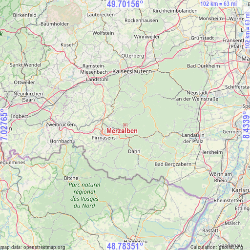
Merzalben GPS coordinates[2]
49° 14' 40.812" North, 7° 43' 50.772" East
| Map corner | latitude | longitude |
|---|---|---|
| Upper-left | 49.70156°, | 7.02765° |
| Center: | 49.24467°, | 7.73077° |
| Lower-right: | 48.78351°, | 8.4339° |
| Map W x H: | 102.1×102.1 km | = 63.4×63.4mi |
| max Lat: | 55.01917° ⇑79.7% North |
| Merzalben: | 49.24467° |
| min Lat: | ⇓20.3% South 47.40724° |
| min Long | Merzalben | max Long |
| 5.92978° | 7.73077° | 14.98853° |
| W 17.5%⇐ | ⇒82.5% E |
Elevation
Elevation of Merzalben is 288 m = 945 ft, and this is 38.9 m = 128 ft above average elevation for this country.
| Max E: |
1256 m = 4121 ft | 40.3% |
| Merzalben | 288 m 945 ft | |
| Avg. | 249.1 m = 817 ft | |
Min E: |
-5 m = -16 ft | 59.7% |
See also: Germany elevation on elevation.city.
Geographical zone
Merzalben is located in North temperate zone (between Tropic of Cancer and the Arctic Circle). Distance of this North polar circle is 1925.7 km =1196.6 mi to North.| Distance of | km | miles | from Merzalben |
|---|---|---|---|
| North Pole | 4531.6 | 2815.8 | to North |
| Arctic Circle | 1925.7 | 1196.6 | to North |
| Tropic Cancer | 2869.6 | 1783.1 | to South |
| Equator | 5475.5 | 3402.3 | to South |


Nearby cities:
15 places around Merzalben: (largest is in red/bold)
• Clausen
4.3 km =2.7 mi,  294°
294°
• Donsieders
6.8 km =4.2 mi, 289°
• Geiselberg
9.4 km =5.8 mi,  344°
344°
• Heltersberg
8.1 km =5 mi,  352°
352°
• Hinterweidenthal
5.2 km =3.2 mi,  164°
164°
• Höheinöd
10.3 km =6.4 mi,  299°
299°
• Leimen
4.2 km =2.6 mi,  40°
40°
• Lemberg
9.8 km =6.1 mi,  216°
216°
• Münchweiler an der Rodalbe
3.6 km =2.2 mi,  214°
214°
• Pirmasens
10.3 km =6.4 mi,  242°
242°
• Rodalben
6.6 km =4.1 mi,  264°
264°
• Ruppertsweiler
6.1 km =3.8 mi, 209°
• Schmalenberg
9.9 km =6.2 mi,  1°
1°
• Steinalben
9.9 km =6.2 mi,  323°
323°
• Waldfischbach-Burgalben
6.3 km =3.9 mi,  312°
312°
Sources, notices
• [Note1] Compared only with cities in Germany existing in our database
• [Src1] Map data: © OpenStreetMap contributors (CC-BY-SA)
• [Src2] Other city data from geonames.org with taken over terms of usage.
• [Src3] Geographical zone / Annual Mean Temperature by Robert A. Rohde @ Wikipedia
